
Belasitsa Sky Run 2018
ITRA
 67.4 km
2810 m
2810 m
67.4 km
2810 m
2810 m

GPX
7
PDF
Profil
Partager
3D
Favoris
Avis
J'aime
?????? / Petrich (BG) ?????? / Petrich (BG)
Kilomètre effort
Plus longue montée
Plus longue descente
95
1920 m
1720 m
Altitude max
Altitude min
Indice de qualité
2008 m
184 m
 1pt/28m
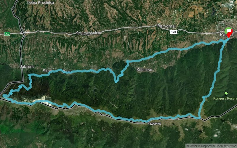
Belasitsa Sky Run is a trail running race that follows the ridge of one of the mountains with the most beautiful panoramas on the Balkan Peninsula.
During the event the participants will enjoy views of three countries (Bulgaria, FYR Macedonia and Greece) and will see the three highest mountains on the Balkans (Rila, Olympus and Pirin). Two beautiful lakes (Dojran and Kerkini) make the panoramas even more breathtaking, while Struma River valley and the picturesque villages at the foot of the Mountain add to the atmosphere of the race part of which runs in midst of the centuries-old chestnut forests - the symbol of Belasitsa Mountain.
The route of Belasitsa Sky Run is 67,4 km long and starts from Petrich, passes along some of the villages at the foothills of the Mountain, climbs to the Shy (Kamenishki) waterfall and continues west to the Macedonian border before climbing to the main mountain ridge and afterwards follows the whole Bulgarian part of the panoramic ridge by the highest peak of Belasitsa - Radomir (2029 m.a.s.l.) to Kongur Peak and descends through centuries-old beech and chestnut forests to the finish in Petrich.
En voir plus... En voir moins...
Trace créée par Bela Extreme
le 16/07/2018 (modifiée le 24/07/2018)
le 16/07/2018 (modifiée le 24/07/2018)

Départ
Distance
0 km
Altitude
222 m
D+
0 m
D-
0 m
67.4 km
2810 m
2810 m
Arrivée
Distance
67.4 km
Altitude
222 m
D+
2810 m
D-
2810 m
Cliquez sur un point d'intérêt pour l'afficher sur la carte
Avis et chronos
Ajouter une trace
Belasitsa Sky Run 2018

Numéro de trace : 63733
Lien vers la trace :
https://tracedetrail.fr/fr/trace/63733
Connectez-vous pour insérer cette trace sur votre site web
 Trace de Trail