
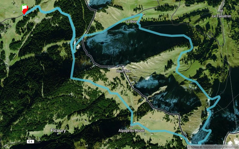
Tour Pointe du Mouet & Haut Sex
 8.9 km
521 m
517 m
8.9 km
521 m
517 m
GPX
69
PDF
Profile
Share
3D
Favorites
Reviews
Like
Parking Sevant Devant (74) Parking Sevant Devant (74)
Effort kilometer
Longest ascent
Longest descent
14
230 m
208 m
Max. elevation
Min. elevation
Quality index
1799 m
1545 m
 1pt/22m
From the parking you follow the dirt road up to Col de Recon, there you descend to the restaurant at La Bourri and turn left to follow the trail along the mountain side to the farm at Chétillon, continue and at the next farm you turn right to Col de Reculaz. Turn right to Chalet de Mouet for a well deserved drink and meal. Then continue at the same altitude along the mountain side, path starts behind the farm, and descend to the dirt road that you follow back to the car.
En voir plus... En voir moins...

Start
Distance
0 km
Altitude
1573 m
D+
0 m
D-
0 m
8.9 km
521 m
517 m
Finish
Distance
8.9 km
Altitude
1573 m
D+
521 m
D-
517 m
Click on a point of interest to display it on the map
Reviews and times
Add a track
Tour Pointe du Mouet & Haut Sex

Track number : 3773
Link to track :
https://tracedetrail.fr/en/trace/3773
Log in to insert this track on your website
 Trace de Trail