
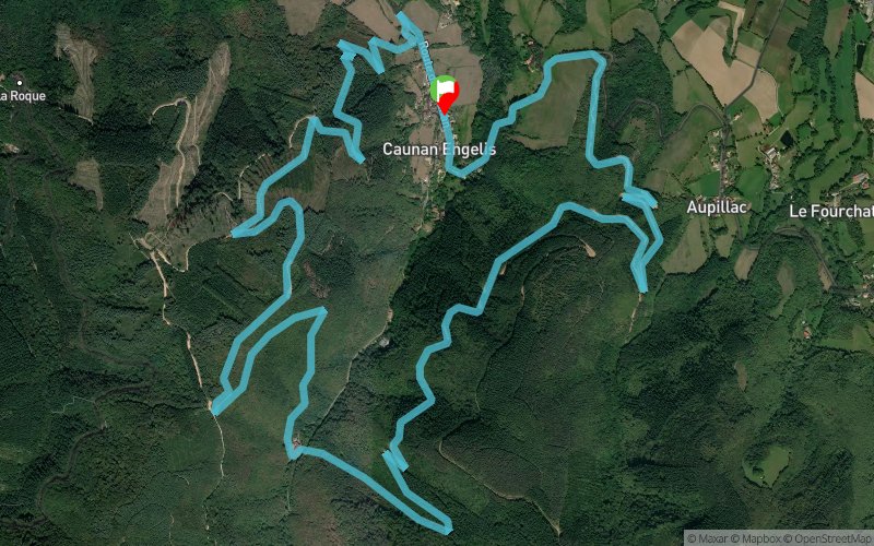
Caunan Engelis - Astruc - Bois des Garrigues - Bois de Nougarède
 12.6 km
580 m
580 m
12.6 km
580 m
580 m
GPX
3
PDF
Profile
Share
3D
Favorites
Reviews
19 Like
Caucalières (81) Caucalières (81)
Effort kilometer
Longest ascent
Longest descent
18
330 m
190 m
Max. elevation
Min. elevation
Quality index
564 m
289 m
 1pt/23m
Start
Distance
0 km
Altitude
303 m
D+
0 m
D-
0 m
12.6 km
580 m
580 m
Finish
Distance
12.6 km
Altitude
303 m
D+
580 m
D-
580 m
Click on a point of interest to display it on the map
Reviews and times
deyan2024/03/31
2024/03/31 01:12:50
2024/03/31 01:12:50
EF
deyan2023/08/06
2023/08/06 01:09:41
2023/08/06 01:09:41
EF
deyan2023/06/25
2023/06/25 01:10:04
2023/06/25 01:10:04
EF
deyan2023/03/19
2023/03/19 01:05:08
2023/03/19 01:05:08
TEMPO
deyan2023/01/22
2023/01/22 01:17:05
2023/01/22 01:17:05
EF
deyan2022/12/18
2022/12/18 01:16:56
2022/12/18 01:16:56
EF
deyan2022/08/15
2022/08/15 01:10:09
2022/08/15 01:10:09
EF
deyan2022/03/20
2022/03/20 01:13:53
2022/03/20 01:13:53
EF
deyan2022/01/23
2022/01/23 01:10:38
2022/01/23 01:10:38
EF+
deyan2021/12/26
2021/12/26 01:08:53
2021/12/26 01:08:53
tempo
deyan2021/09/16
2021/09/15 01:13:39
2021/09/15 01:13:39
tempo (-)
marche en montée
deyan2021/04/03
2021/04/03 01:09:38
2021/04/03 01:09:38
EF
deyan2021/02/06
2021/02/06 01:10:30
2021/02/06 01:10:30
EF
Vent fort
fourmis + genou gauche
deyan2021/01/24
2021/01/23 01:08:17
2021/01/23 01:08:17
EF
deyan2020/10/25
2020/10/25 01:05:15
2020/10/25 01:05:15
EF 10'
Tempo
deyan2020/08/30
2020/08/30 01:03:41
2020/08/30 01:03:41
deyan2020/08/09
2020/08/09 01:09:32
2020/08/09 01:09:32
A jeun.
Chaleur+++
deyan2020/07/11
2020/07/11 01:06:59
2020/07/11 01:06:59
pas de fourmis
deyan2020/07/04
2020/07/04 01:08:29
2020/07/04 01:08:29
Pas de fourmis (léger à 48min -> eau sur pied)
Add a track
Caunan Engelis - Astruc - Bois des Garrigues - Bois de Nougarède

Track number : 120237
Link to track :
https://tracedetrail.fr/en/trace/120237
Log in to insert this track on your website
 Trace de Trail