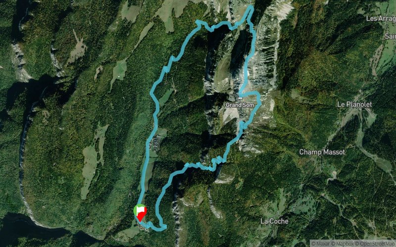
Show the map
Monastère de la Grande Chartreuse - Col de Bovinant - Grand Som - Pas de la Suiffière


14 km
1340 m
1340 m

Points of Interest table
Accum. | Intermediary | |||||||
---|---|---|---|---|---|---|---|---|
POI | Description | Alt. | Dist. | D+ | D- | Dist. | D+ | D- |
Trace n°99568
Ascent threshold : 3 m Distance threshold : 30 m Smoothing : Yes Origin of altitudes : MNT Aster GDEM
Loop
Dominant terrain : Footpath
Max alti. : 2002 m
Avg alti. : 1380 m
Min alti. : 844 m
Longest ascent : 1210 m
Longest descent : 740 m
Route completed by the author : No
Dominant terrain : Footpath
Max alti. : 2002 m
Avg alti. : 1380 m
Min alti. : 844 m
Longest ascent : 1210 m
Longest descent : 740 m
Route completed by the author : No
Elevation profile

Their last tracks
Val Pelouse - Col de la Perrière - Les Grands Moulins - Chalets du Gargoton
14 km
1320 m
1320 m
Arvillard (73)
Croix de Châtel - Le Chalmieu - Le Pré Naret - La Plaigne
18.3 km
1120 m
1120 m
Albiez-Montrond (73)
Col de la Croix Fer - Glacier de l'Étendard - Col du Glandon - Lac de la Croix
25.3 km
1620 m
1260 m
Saint-Sorlin-d’Arves (73)
More tools
Create a new roadbook page
Carte à la Carte IGN
Map and track on your website
Warning ! When you insert a Trace de Trail map on your website, you agree not to hide any element of the module (links to Trail Trail or Trail Connect banner)
Add a realisation
Validate
Add a realisation to share your chrono and describe the conditions that you encountered during you trail running !
Add a comment
Validate
Nearby tracks
0.0 km Col de la Ruchère par le Habert de Billon - Les Spinosiens
11.1 km
732 m
729 m
Saint-Pierre-de-Chartreuse (38)
0.0 km Belvédère d'Arpisson à partir de la correrie
13.3 km
746 m
735 m
Saint-Pierre-de-Chartreuse (38)
0.1 km La Correrie - Col du Frenay - Grand Som - Col de Bovinant - Monastère de la Grande Chartreuse
13.7 km
1250 m
1250 m
Saint-Pierre-de-Chartreuse (38)
0.1 km Monastère de la Grande Chartreuse - Col de la Ruchère
13 km
810 m
820 m
Saint-Pierre-de-Chartreuse (38)
0.1 km Autour de la Grande Chartreuse - les Spinosiens
11.5 km
885 m
882 m
Saint-Pierre-de-Chartreuse (38)
0.1 km Le Grand SOM à partir de la Correrie (par la Suiffière)
14 km
1292 m
1286 m
Saint-Pierre-de-Chartreuse (38)
0.1 km Boucle depuis La Correrie, vers la Suiffière - Grand Som - Col de Bovinant
14.7 km
1258 m
1257 m
Saint-Pierre-de-Chartreuse (38)
0.2 km La Correrie - La Suffière - Grand Som - Petit Som - Col de la Ruchère
15.5 km
1440 m
1440 m
Saint-Pierre-de-Chartreuse (38)
0.2 km Sentier empreintes et vocations - Chartreuse
8.6 km
588 m
579 m
Saint-Pierre-de-Chartreuse (38)
0.2 km Col de la ruchère - Grand Som - La Suiffière
16.6 km
1310 m
1310 m
Saint-Pierre-de-Chartreuse (38)
0.3 km Grand Som - Lances de Malissard - Dent de Crolles - Chamechaude
60.1 km
4960 m
4950 m
Saint-Pierre-de-Chartreuse (38)
0.3 km La Suiffière - Grand Som - Col de Bovinant - Monastère de la Grande Chartreuse
14 km
1210 m
1220 m
Saint-Pierre-de-Chartreuse (38)
Show the infos
Add a track