Show the map
Les Planches - Caux
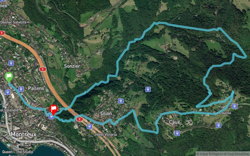


9.4 km
790 m
750 m
 Montreux (CH)
 Montreux (CH)
 Points of Interest table
| Accum. | Intermediary | |||||||
|---|---|---|---|---|---|---|---|---|
| POI | Description | Alt. | Dist. | D+ | D- | Dist. | D+ | D- |
Trace n°96295
Ascent threshold : 3 m Distance threshold : 30 m Smoothing : Yes Origin of altitudes : MNT Aster GDEM
Ascent threshold : 3 m Distance threshold : 30 m Smoothing : Yes Origin of altitudes : MNT Aster GDEM
Loop
Dominant terrain : Path
Max alti. : 1159 m
Avg alti. : 810 m
Min alti. : 404 m
Longest ascent : 790 m
Longest descent : 710 m
Route completed by the author : Yes
Dominant terrain : Path
Max alti. : 1159 m
Avg alti. : 810 m
Min alti. : 404 m
Longest ascent : 790 m
Longest descent : 710 m
Route completed by the author : Yes
Elevation profile
More tools
Create a new roadbook page
Map and track on your website
Warning ! When you insert a Trace de Trail map on your website, you agree not to hide any element of the module (links to Trail Trail or Trail Connect banner)
Add a realisation
Validate
Add a realisation to share your chrono and describe the conditions that you encountered during you trail running !
Add a comment
Validate
Winzenried
17/04/20, 17:22:50
Je suis parti des Planches pour éviter le bas de Montreux. Itinéraire sympa avec montée plutôt constante. J'ai poussé jusqu'aux Avants et suis redescendu par la route des Avants pour rejoindre l'itinéraire juste avant le 4ème kilomètre.
17/04/20, 17:22:50
Je suis parti des Planches pour éviter le bas de Montreux. Itinéraire sympa avec montée plutôt constante. J'ai poussé jusqu'aux Avants et suis redescendu par la route des Avants pour rejoindre l'itinéraire juste avant le 4ème kilomètre.
Show the infos
Add a track


