Show the map
Certified Track - ITRA
X-Treme Run 50km 2019
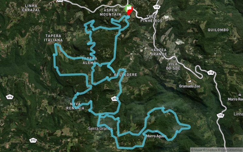


47.4 km
1890 m
1890 m
 Gramado (BR)
 4
4 320
320
O percurso da X-treme Run 50km tem variantes de todos os níveis e graus de dificuldades.
Points of Interest table
| Accum. | Intermediary | |||||||
|---|---|---|---|---|---|---|---|---|
| POI | Description | Alt. | Dist. | D+ | D- | Dist. | D+ | D- |
 Competition organized on 10/05/2019
Trace n°96168
Ascent threshold : 3 m Distance threshold : 0 m Smoothing : No Origin of altitudes : GPS
Ascent threshold : 3 m Distance threshold : 0 m Smoothing : No Origin of altitudes : GPS
Loop
Dominant terrain : Footpath
Max alti. : 872 m
Avg alti. : 722 m
Min alti. : 446 m
Longest ascent : 280 m
Longest descent : 450 m
Dominant terrain : Footpath
Max alti. : 872 m
Avg alti. : 722 m
Min alti. : 446 m
Longest ascent : 280 m
Longest descent : 450 m
Elevation profile
More tools
Create a new roadbook page
Map and track on your website
Warning ! When you insert a Trace de Trail map on your website, you agree not to hide any element of the module (links to Trail Trail or Trail Connect banner)
Add a realisation
Validate
Add a realisation to share your chrono and describe the conditions that you encountered during you trail running !
Add a comment
Validate
Admin - Trace de Trail
02/09/19, 21:26:27
Bonjour, Merci de ne laisser en public qu'une unique trace pour la même épreuve d'une compétition.
02/09/19, 21:26:27
Bonjour, Merci de ne laisser en public qu'une unique trace pour la même épreuve d'une compétition.
Show the infos
Add a track


