Show the map
Trail de Minuit 2019
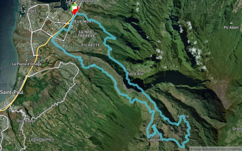


60.5 km
3390 m
3390 m
 La Possession (RE)
 Points of Interest table
| Accum. | Intermediary | |||||||
|---|---|---|---|---|---|---|---|---|
| POI | Description | Alt. | Dist. | D+ | D- | Dist. | D+ | D- |
 Competition organized on 06/09/2019
Trace n°89466
Ascent threshold : 3 m Distance threshold : 30 m Smoothing : Yes Origin of altitudes : MNT IGN
Ascent threshold : 3 m Distance threshold : 30 m Smoothing : Yes Origin of altitudes : MNT IGN
Loop
Dominant terrain : Footpath
Max alti. : 960 m
Avg alti. : 549 m
Min alti. : 18 m
Longest ascent : 1240 m
Longest descent : 710 m
Dominant terrain : Footpath
Max alti. : 960 m
Avg alti. : 549 m
Min alti. : 18 m
Longest ascent : 1240 m
Longest descent : 710 m
Elevation profile
More tools
Create a new roadbook page
Map and track on your website
Warning ! When you insert a Trace de Trail map on your website, you agree not to hide any element of the module (links to Trail Trail or Trail Connect banner)
Add a realisation
Validate
Add a realisation to share your chrono and describe the conditions that you encountered during you trail running !
Add a comment
Validate
Admin - Trace de Trail
13/06/19, 21:01:43
A la Réunion, il est vraiment conseillé d'utiliser le MNT IGN pour calculer le profil de votre trace...
13/06/19, 21:01:43
A la Réunion, il est vraiment conseillé d'utiliser le MNT IGN pour calculer le profil de votre trace...
Show the infos
Add a track


