Show the map
Hemera Trail 2019 - Trail du Château
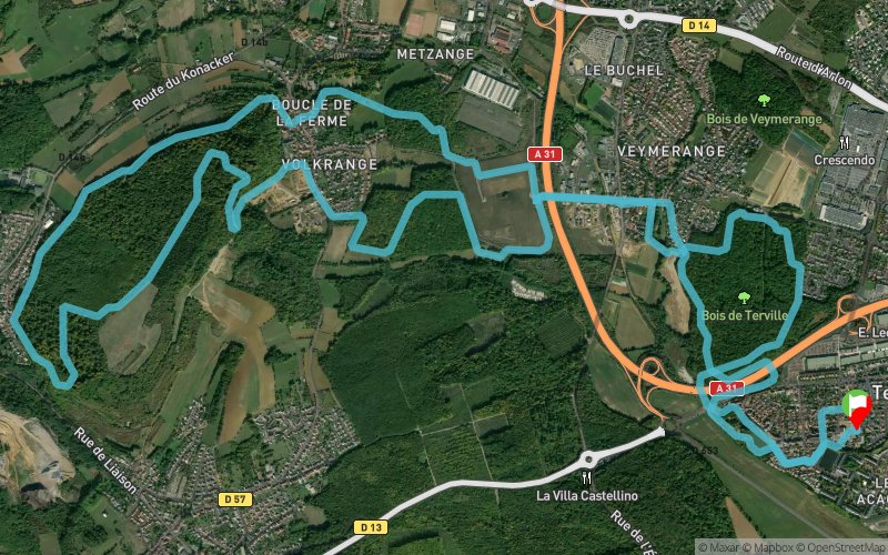


18.1 km
430 m
430 m
 Terville (57)
 Points of Interest table
| Accum. | Intermediary | |||||||
|---|---|---|---|---|---|---|---|---|
| POI | Description | Alt. | Dist. | D+ | D- | Dist. | D+ | D- |
 Competition organized on 06/04/2019
Trace n°88659
Ascent threshold : 1 m Distance threshold : 5 m Smoothing : Yes Origin of altitudes : MNT IGN
Ascent threshold : 1 m Distance threshold : 5 m Smoothing : Yes Origin of altitudes : MNT IGN
Loop
Dominant terrain : Path
Max alti. : 330 m
Avg alti. : 210 m
Min alti. : 159 m
Longest ascent : 130 m
Longest descent : 270 m
Dominant terrain : Path
Max alti. : 330 m
Avg alti. : 210 m
Min alti. : 159 m
Longest ascent : 130 m
Longest descent : 270 m
Elevation profile
More tools
Create a new roadbook page
Map and track on your website
Warning ! When you insert a Trace de Trail map on your website, you agree not to hide any element of the module (links to Trail Trail or Trail Connect banner)
Add a realisation
Validate
Add a realisation to share your chrono and describe the conditions that you encountered during you trail running !
Add a comment
Validate
Vaxxin
27/03/22, 13:14:02
La trace est déviée au niveau de la rue des futaies (zone commerciale) et certains chemins n’existent plus
27/03/22, 13:14:02
La trace est déviée au niveau de la rue des futaies (zone commerciale) et certains chemins n’existent plus
Show the infos
Add a track


