Show the map
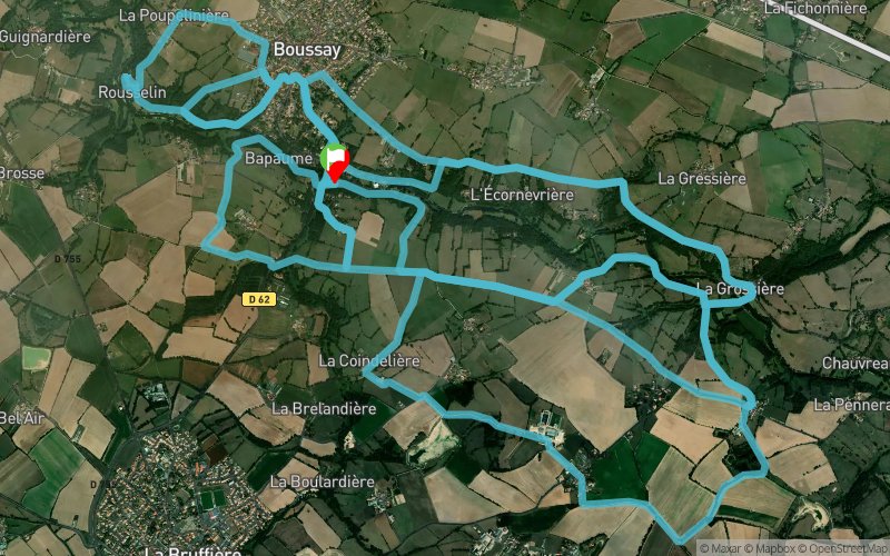
La Colardière - Rousselin - La Grossière - Le Recredy - La Poinsetière


34.7 km
650 m
650 m

Points of Interest table
Accum. | Intermediary | |||||||
---|---|---|---|---|---|---|---|---|
POI | Description | Alt. | Dist. | D+ | D- | Dist. | D+ | D- |
Trace n°83870
Ascent threshold : 3 m Distance threshold : 30 m Smoothing : No Origin of altitudes : MNT Aster GDEM
Loop
Dominant terrain : Path
Max alti. : 93 m
Avg alti. : 64 m
Min alti. : 0 m
Longest ascent : 90 m
Longest descent : 70 m
Route completed by the author : No
Dominant terrain : Path
Max alti. : 93 m
Avg alti. : 64 m
Min alti. : 0 m
Longest ascent : 90 m
Longest descent : 70 m
Route completed by the author : No
Elevation profile

Their last tracks
Cugand - Clisson - Gorges - Sainte-Lumine - Saint-Hilaire - La Bernardière
49 km
630 m
630 m
Treize-Septiers (85)
Bois des Jarries - La Bessonière - St-Michel-Mont-Mercure
30.8 km
970 m
970 m
Saint-Mars-la-Réorthe (85)
Le Bois Joly d'Ardelay - La Bretonnière - Bois des Jarries - Les Epesses
35.2 km
890 m
890 m
Saint-Mars-la-Réorthe (85)
More tools
Create a new roadbook page
Carte à la Carte IGN
Map and track on your website
Warning ! When you insert a Trace de Trail map on your website, you agree not to hide any element of the module (links to Trail Trail or Trail Connect banner)
Add a realisation
Validate
Add a realisation to share your chrono and describe the conditions that you encountered during you trail running !
Add a comment
Validate
Nearby tracks
0.0 km Le Pré de Sèvre - Boussay - Le Rousselin - La Poupelinière - La Colardière - Bapaume
25.5 km
460 m
460 m
Boussay (44)
8.1 km Le Couboureau - Barrage des Rivières - Pont de Grenon - Villeneuve
20.7 km
290 m
300 m
Tiffauges (85)
8.4 km Chauvreau - La Grossière - Boussay - La Poinsetière - Le Plessis
25.1 km
550 m
550 m
Tiffauges (85)
Show the infos
Add a track