Show the map
Trail de Mirmande 2015 - 12km
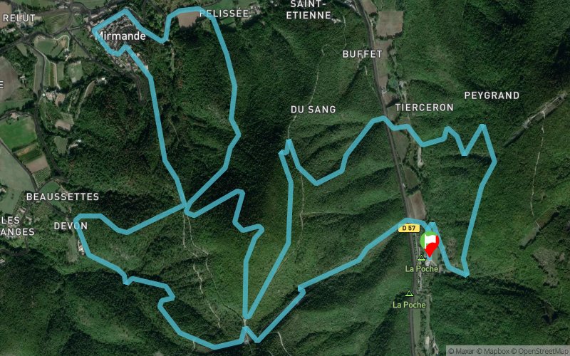


11.6 km
807 m
802 m
 Mirmande (26)
 Points of Interest table
| Accum. | Intermediary | |||||||
|---|---|---|---|---|---|---|---|---|
| POI | Description | Alt. | Dist. | D+ | D- | Dist. | D+ | D- |
 Competition organized on 03/28/2015
Trace n°7522
Ascent threshold : 3 m Distance threshold : 30 m Smoothing : Yes Origin of altitudes : MNT Aster GDEM
Ascent threshold : 3 m Distance threshold : 30 m Smoothing : Yes Origin of altitudes : MNT Aster GDEM
Loop
Dominant terrain : Footpath
Max alti. : 490 m
Avg alti. : 304 m
Min alti. : 176 m
Longest ascent : 229 m
Longest descent : 333 m
Dominant terrain : Footpath
Max alti. : 490 m
Avg alti. : 304 m
Min alti. : 176 m
Longest ascent : 229 m
Longest descent : 333 m
Elevation profile
More tools
Create a new roadbook page
Map and track on your website
Warning ! When you insert a Trace de Trail map on your website, you agree not to hide any element of the module (links to Trail Trail or Trail Connect banner)
Add a realisation
Validate
Add a realisation to share your chrono and describe the conditions that you encountered during you trail running !
Add a comment
Validate
Cécile
27/04/15, 21:02:48
Qu'est-ce qu'il t'arrive Juliette, t'es malade ? petite forme ? ou simplement footing de récup' ? Une trace de 12km de ta part, c'est assez rare ;-)
27/04/15, 21:02:48
Qu'est-ce qu'il t'arrive Juliette, t'es malade ? petite forme ? ou simplement footing de récup' ? Une trace de 12km de ta part, c'est assez rare ;-)
Show the infos
Add a track


