
UTMB® 2016 - UTMB®
ITRA
 169.6 km
10060 m
10060 m
169.6 km
10060 m
10060 m

GPX
159
PDF
Profile
Share
3D
Favorites
Reviews
Like
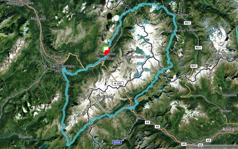
Chamonix-Mont-Blanc (74) Chamonix-Mont-Blanc (74)
Effort kilometer
Longest ascent
Longest descent
270
1360 m
1700 m
Max. elevation
Min. elevation
Quality index
2569 m
799 m
 1pt/20m
Track created by Ultra-Trail du Mont-Blanc
le 2015/04/23 (modified on 2022/09/30)
le 2015/04/23 (modified on 2022/09/30)


Chamonix
Distance
0 km
Altitude
1038 m
D+
0 m
D-
0 m
7.8 km
132 m
163 m
Les Houches
Distance
7.8 km
Altitude
1008 m
D+
132 m
D-
163 m
13.1 km
834 m
1034 m
Saint-Gervais
Distance
20.9 km
Altitude
807 m
D+
966 m
D-
1197 m
10.1 km
596 m
246 m
Les Contamines
Distance
31.1 km
Altitude
1157 m
D+
1562 m
D-
1443 m
8.1 km
566 m
13 m
La Balme
Distance
39.2 km
Altitude
1710 m
D+
2128 m
D-
1456 m
5 km
780 m
15 m
Croix du Bonhomme
Distance
44.3 km
Altitude
2475 m
D+
2908 m
D-
1471 m
5.5 km
13 m
941 m
Les Chapieux
Distance
49.8 km
Altitude
1546 m
D+
2921 m
D-
2412 m
10.3 km
1003 m
38 m
Col de la Seigne
Distance
60.1 km
Altitude
2513 m
D+
3924 m
D-
2450 m
6.1 km
270 m
812 m
Lac Combal
Distance
66.3 km
Altitude
1969 m
D+
4194 m
D-
3262 m
4.1 km
461 m
18 m
Arête du Mont Favre
Distance
70.5 km
Altitude
2412 m
D+
4655 m
D-
3280 m
4.5 km
21 m
478 m
Col Chécrouit
Distance
75 km
Altitude
1954 m
D+
4676 m
D-
3758 m
4.1 km
6 m
769 m
Courmayeur
Distance
79.2 km
Altitude
1193 m
D+
4682 m
D-
4527 m
4.7 km
802 m
26 m
Refuge Bertone
Distance
84 km
Altitude
1969 m
D+
5484 m
D-
4553 m
7.4 km
302 m
246 m
Refuge Bonatti
Distance
91.4 km
Altitude
2025 m
D+
5786 m
D-
4799 m
5.1 km
147 m
401 m
Arnuva
Distance
96.5 km
Altitude
1771 m
D+
5933 m
D-
5200 m
4.4 km
761 m
6 m
Grand Col Ferret
Distance
101 km
Altitude
2526 m
D+
6694 m
D-
5206 m
9.6 km
98 m
1022 m
La Fouly
Distance
110.7 km
Altitude
1600 m
D+
6792 m
D-
6228 m
13.9 km
583 m
712 m
Champex-Lac
Distance
124.6 km
Altitude
1473 m
D+
7375 m
D-
6940 m
4.9 km
104 m
222 m
Plan de l'Au
Distance
129.6 km
Altitude
1356 m
D+
7479 m
D-
7162 m
11.2 km
783 m
836 m
Trient
Distance
140.9 km
Altitude
1300 m
D+
8262 m
D-
7998 m
4.9 km
800 m
57 m
Catogne
Distance
145.8 km
Altitude
2045 m
D+
9062 m
D-
8055 m
5.3 km
21 m
803 m
Vallorcine
Distance
151.1 km
Altitude
1262 m
D+
9083 m
D-
8858 m
3.7 km
194 m
0 m
Col des Montets
Distance
154.9 km
Altitude
1458 m
D+
9277 m
D-
8858 m
3.9 km
691 m
17 m
La Tête aux Vents
Distance
158.9 km
Altitude
2131 m
D+
9968 m
D-
8875 m
3.4 km
71 m
313 m
La Flégère
Distance
162.3 km
Altitude
1888 m
D+
10039 m
D-
9188 m
7.2 km
21 m
872 m
Finish
Distance
169.6 km
Altitude
1038 m
D+
10060 m
D-
10060 m
Chamonix,
Click on a point of interest to display it on the map
Reviews and times
Add a track
UTMB® 2016 - UTMB®

Track number : 7359
Link to track :
https://tracedetrail.fr/en/trace/7359
Log in to insert this track on your website
 Trace de Trail