Show the map
La Fillonière - Vendessieux - St-Sorlin
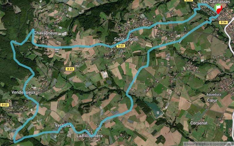


14.3 km
510 m
510 m
 Mornant (69)
 Points of Interest table
| Accum. | Intermediary | |||||||
|---|---|---|---|---|---|---|---|---|
| POI | Description | Alt. | Dist. | D+ | D- | Dist. | D+ | D- |
Trace n°72451
Ascent threshold : 3 m Distance threshold : 30 m Smoothing : Yes Origin of altitudes : MNT Aster GDEM
Ascent threshold : 3 m Distance threshold : 30 m Smoothing : Yes Origin of altitudes : MNT Aster GDEM
Loop
Dominant terrain : Path
Max alti. : 724 m
Avg alti. : 501 m
Min alti. : 355 m
Longest ascent : 270 m
Longest descent : 390 m
Route completed by the author : No
Dominant terrain : Path
Max alti. : 724 m
Avg alti. : 501 m
Min alti. : 355 m
Longest ascent : 270 m
Longest descent : 390 m
Route completed by the author : No
Elevation profile
More tools
Create a new roadbook page
Map and track on your website
Warning ! When you insert a Trace de Trail map on your website, you agree not to hide any element of the module (links to Trail Trail or Trail Connect banner)
Add a realisation
Validate
Add a realisation to share your chrono and describe the conditions that you encountered during you trail running !
Add a comment
Validate
papy-trail
05/12/23, 18:39:07
Parcours pas très intéressant la première partie est assez monotone et hormis un passage dans les bois sympa le retour se fait par la route avec beaucoup de goudron finalement. Par ailleurs peu après le kilomètre 2 le sentier est interrompu probablement à cause d'un champ mis en culture il faut descendre à gauche puis prendre à droite le chemin de la fillonnière pour rejoindre le tracé.
Show the infos
Add a track


