Show the map
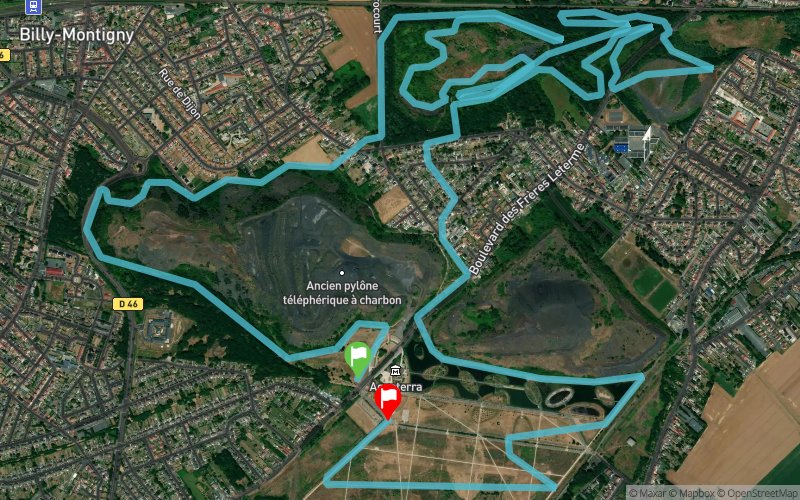
Trail des Îles 2018 - 11 km


12.2 km
300 m
290 m


Points of Interest table
Accum. | Intermediary | |||||||
---|---|---|---|---|---|---|---|---|
POI | Description | Alt. | Dist. | D+ | D- | Dist. | D+ | D- |

Trace n°71862
Ascent threshold : 3 m Distance threshold : 30 m Smoothing : No Origin of altitudes : MNT Aster GDEM
Loop
Dominant terrain : Footpath
Max alti. : 72 m
Avg alti. : 40 m
Min alti. : 15 m
Longest ascent : 50 m
Longest descent : 60 m
Dominant terrain : Footpath
Max alti. : 72 m
Avg alti. : 40 m
Min alti. : 15 m
Longest ascent : 50 m
Longest descent : 60 m
Elevation profile

Their last tracks
More tools
Create a new roadbook page
Carte à la Carte IGN
Map and track on your website
Warning ! When you insert a Trace de Trail map on your website, you agree not to hide any element of the module (links to Trail Trail or Trail Connect banner)
Add a realisation
Validate
Add a realisation to share your chrono and describe the conditions that you encountered during you trail running !
Add a comment
Validate
Nearby tracks
1.6 km Parc de la Glissoire - Mont de Givenchy - Forêt de Vimy - Farbus - Méricourt
56.4 km
630 m
630 m
Billy-Montigny (62)
5.1 km Les Vingt-Huit - Base de Loisirs du Pommier - Parc des Îles
21.7 km
600 m
590 m
Hénin-Beaumont (62)
12.0 km Crêtes de Pinchonvalles - Givenchy-en-Gohelle - N.-D. de Lorette - Aix-Noulette
40 km
1110 m
1090 m
Éleu-dit-Leauwette (62)
Show the infos
Add a track