Show the map
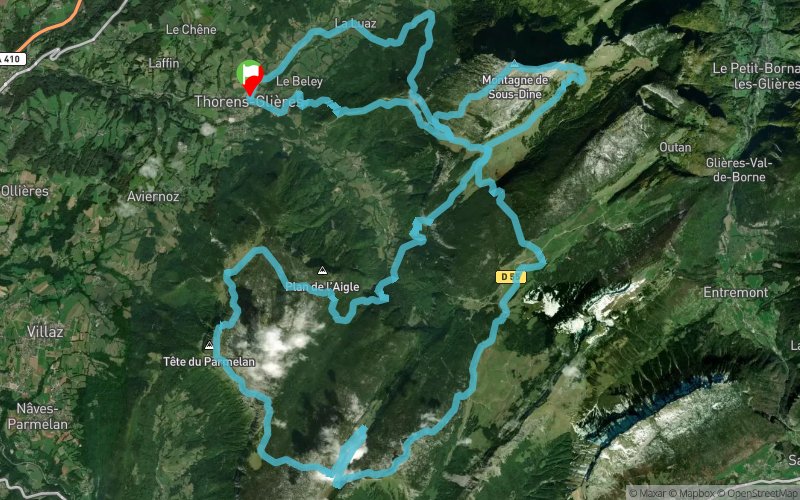
Trail des Glières 2017


65.7 km
4630 m
4630 m

Points of Interest table
Accum. | Intermediary | |||||||
---|---|---|---|---|---|---|---|---|
POI | Description | Alt. | Dist. | D+ | D- | Dist. | D+ | D- |

Trace n°67868
Ascent threshold : 3 m Distance threshold : 30 m Smoothing : No Origin of altitudes : MNT Aster GDEM
Loop
Dominant terrain : Path
Max alti. : 2011 m
Avg alti. : 1416 m
Min alti. : 659 m
Longest ascent : 1260 m
Longest descent : 1460 m
Dominant terrain : Path
Max alti. : 2011 m
Avg alti. : 1416 m
Min alti. : 659 m
Longest ascent : 1260 m
Longest descent : 1460 m
Elevation profile

Their last tracks
Lac d'Annecy - Morat - Col des Contrebandiers - Sentier du Milieu
23.8 km
1200 m
1200 m
Annecy-le-Vieux (74)
Lac d'Annecy - Pas de l'Échelle - Le Couvent - Rochers des Becs
14.7 km
710 m
710 m
Annecy-le-Vieux (74)
Verthier - Col de la Forclaz - Col des Nantets - Pointe de Talamarche - Roc Lancrenaz
31.7 km
2570 m
2570 m
Doussard (74)
More tools
Create a new roadbook page
Carte à la Carte IGN
Map and track on your website
Warning ! When you insert a Trace de Trail map on your website, you agree not to hide any element of the module (links to Trail Trail or Trail Connect banner)
Add a realisation
Validate
Add a realisation to share your chrono and describe the conditions that you encountered during you trail running !
Add a comment
Validate
Nearby tracks
0.0 km Montagne de Sous-Dine - Tête Ronde - Chalet de Landron
59.9 km
4110 m
4110 m
Thorens-Glières (74)
0.0 km La Luaz - Col de Landron - Col des Glières - Pas du Roc - Usillon
33.8 km
2190 m
2190 m
Thorens-Glières (74)
0.0 km La Luaz - Col de l'Enclave - Col de l'Ébat - Sous Dîne
26.4 km
1690 m
1690 m
Thorens-Glières (74)
Show the infos
Add a track