Show the map
OFFICIAL ROUTE
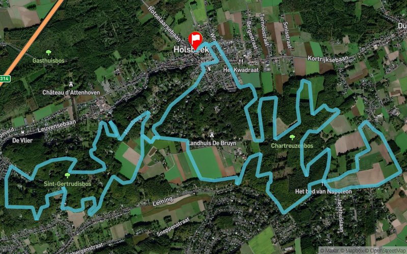
Hageland Trail 2023 - 21 km


21.6 km
580 m
580 m
 Holsbeek (BE)
 Holsbeek (BE)
 Points of Interest table
| Accum. | Intermediary | |||||||
|---|---|---|---|---|---|---|---|---|
| POI | Description | Alt. | Dist. | D+ | D- | Dist. | D+ | D- |
 Competition organized on 01/15/2023
Trace n°65437
Ascent threshold : 3 m Distance threshold : 30 m Smoothing : Yes Origin of altitudes : MNT Aster GDEM
Ascent threshold : 3 m Distance threshold : 30 m Smoothing : Yes Origin of altitudes : MNT Aster GDEM
Loop
Dominant terrain : Footpath
Max alti. : 91 m
Avg alti. : 59 m
Min alti. : 10 m
Longest ascent : 80 m
Longest descent : 70 m
Dominant terrain : Footpath
Max alti. : 91 m
Avg alti. : 59 m
Min alti. : 10 m
Longest ascent : 80 m
Longest descent : 70 m
More tools
Create a new roadbook page
Map and track on your website
Warning ! When you insert a Trace de Trail map on your website, you agree not to hide any element of the module (links to Trail Trail or Trail Connect banner)
Add a realisation
Validate
Add a realisation to share your chrono and describe the conditions that you encountered during you trail running !
Add a comment
Validate
Sam Lausberg
12/12/18, 17:44:20
Je l'ai fait en reconnaissance...(12/12/18).. Je me suis super bien amusé... Super parcour...Merci...vivement 6/1/19 Yvan
12/12/18, 17:44:20
Je l'ai fait en reconnaissance...(12/12/18).. Je me suis super bien amusé... Super parcour...Merci...vivement 6/1/19 Yvan
Show the infos
Warning ! This track is only accessible on the day of the competition.
Add a track


