Show the map
Urban Trail des Singes 2018 - 10km
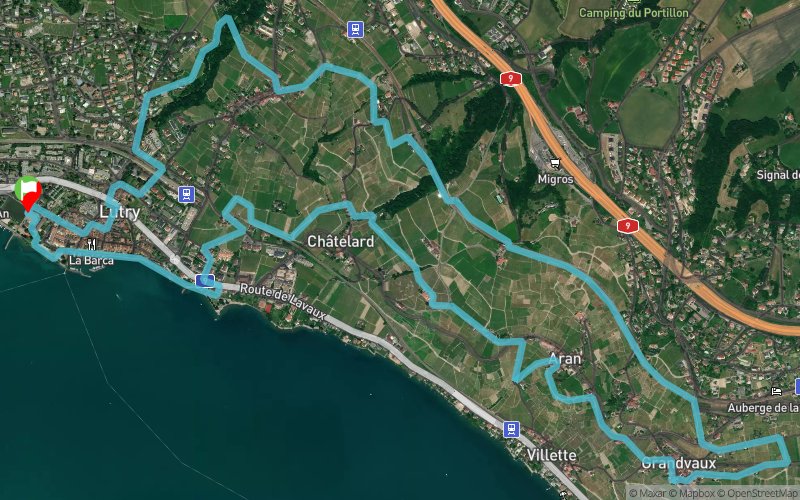


10.4 km
330 m
330 m
 Lutry (CH)
 Points of Interest table
| Accum. | Intermediary | |||||||
|---|---|---|---|---|---|---|---|---|
| POI | Description | Alt. | Dist. | D+ | D- | Dist. | D+ | D- |
 Competition organized on 05/27/2018
Trace n°59284
Ascent threshold : 3 m Distance threshold : 30 m Smoothing : Yes Origin of altitudes : MNT Aster GDEM
Ascent threshold : 3 m Distance threshold : 30 m Smoothing : Yes Origin of altitudes : MNT Aster GDEM
Loop
Dominant terrain : Footpath
Max alti. : 558 m
Avg alti. : 451 m
Min alti. : 369 m
Longest ascent : 210 m
Longest descent : 180 m
Dominant terrain : Footpath
Max alti. : 558 m
Avg alti. : 451 m
Min alti. : 369 m
Longest ascent : 210 m
Longest descent : 180 m
Elevation profile
More tools
Create a new roadbook page
Map and track on your website
Warning ! When you insert a Trace de Trail map on your website, you agree not to hide any element of the module (links to Trail Trail or Trail Connect banner)
Add a realisation
Validate
Add a realisation to share your chrono and describe the conditions that you encountered during you trail running !
Add a comment
Validate
Admin - Trace de Trail
22/05/18, 06:21:33
Bonjour, Il suffit de vous rendre sur la page de modification de votre trace grâce au bouton avec le crayon en haut de cette page. Ensuite, allez simplement modifier la description obligatoire.
22/05/18, 06:21:33
Bonjour, Il suffit de vous rendre sur la page de modification de votre trace grâce au bouton avec le crayon en haut de cette page. Ensuite, allez simplement modifier la description obligatoire.
More comments
Admin - Trace de Trail
19/05/18, 16:33:27
Bonjour, merci de classer votre trace en compétition avant de la placer en public.
19/05/18, 16:33:27
Bonjour, merci de classer votre trace en compétition avant de la placer en public.
Show the infos
Add a track


