Show the map
Certified Track - ITRA
Petzl Trail Plus 2018 - 50 km
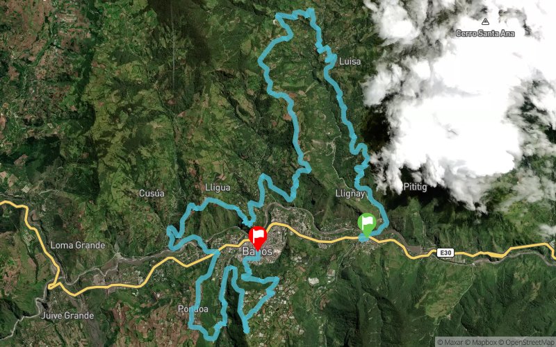


49.7 km
4930 m
4820 m
 Inconnu (ND)
 Inconnu (ND)
 13
13 490
490 Points of Interest table
| Accum. | Intermediary | |||||||
|---|---|---|---|---|---|---|---|---|
| POI | Description | Alt. | Dist. | D+ | D- | Dist. | D+ | D- |
 Competition organized on 05/05/2018
Trace n°55233
Ascent threshold : 3 m Distance threshold : 0 m Smoothing : No Origin of altitudes : GPS + MNT Aster GDEM
Ascent threshold : 3 m Distance threshold : 0 m Smoothing : No Origin of altitudes : GPS + MNT Aster GDEM
Crossing
Dominant terrain : Footpath
Max alti. : 2765 m
Avg alti. : 2188 m
Min alti. : 1676 m
Longest ascent : 800 m
Longest descent : 1130 m
Dominant terrain : Footpath
Max alti. : 2765 m
Avg alti. : 2188 m
Min alti. : 1676 m
Longest ascent : 800 m
Longest descent : 1130 m
Elevation profile
More tools
Create a new roadbook page
Map and track on your website
Warning ! When you insert a Trace de Trail map on your website, you agree not to hide any element of the module (links to Trail Trail or Trail Connect banner)
Add a realisation
Validate
Add a realisation to share your chrono and describe the conditions that you encountered during you trail running !
Add a comment
Validate
Show the infos
Add a track


