Show the map
Evaluated Track - ITRA
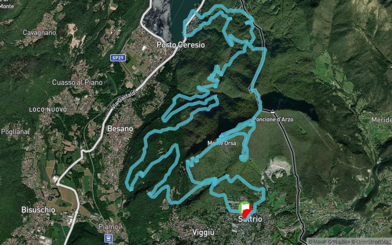
Orsa Pravello Trail 2018


 Saltrio (IT)


The OPT is a mountain running race, which this year is in its 3rd edition. There will be 3 races: 30km, 16km and 7km.
The path of Orsa Pravello GIURASSICO Trail, 30km with 2000mD +, has been renewed with respect to the two previous editions.
With the evocative passages of the Cadorna Line, up to the peak of the Pravello km7, but with some variations, and therefore a fare the peak of the Bear, passing precisely from the famous "antennas".
The track, once at the top of Pravello, will descend from the Swiss side, and will arrive until Monte Casolo. It will cross the village of Cà del Monte and descend to the lake, along a stretch of promenade along Lake Ceresio.
After about a kilometer, I took the paths back to the trenches of Mount Grumello, and moved towards the paths of the Bernasca, in the municipality of Besano, passing through the "Sentiero dei Fossili". From here, you will upgrade to the Sant'Elia hill and then, the last tiring climb before arrival.
The track, with a length of 30km, covers a positive difference in level of 2000m D +.
The path is a qualifying UTMB, and is ITRA certified with the assignment of 2pt.
Technical and nervous, made up of climbs and descents, steps and steps in the trenches, a path suitable for those who love nature and the surprise of new tracks to be discovered.
Same route for the Orsa Pravello TRINCEA Trail, 16km with 1000mD +, up to the peak of Pravello, at km 7, then very technical and steep descent towards the village. In total 16km spaccagambe where you can take a breath only at the finish line.
There will also be a "non-competitive walk" Orsa Pravello MINI Trail, for amateurs who are not interested in the classification, with a route of about 7km.
Points of Interest table
| Accum. | Intermediary | |||||||
|---|---|---|---|---|---|---|---|---|
| POI | Description | Alt. | Dist. | D+ | D- | Dist. | D+ | D- |
 Competition organized on 10/07/2018
Trace n°54515
Ascent threshold : 3 m Distance threshold : 30 m Smoothing : Yes Origin of altitudes : MNT Google
Ascent threshold : 3 m Distance threshold : 30 m Smoothing : Yes Origin of altitudes : MNT Google
Loop
Dominant terrain : Path
Max alti. : 1015 m
Avg alti. : 629 m
Min alti. : 271 m
Longest ascent : 500 m
Longest descent : 760 m
Dominant terrain : Path
Max alti. : 1015 m
Avg alti. : 629 m
Min alti. : 271 m
Longest ascent : 500 m
Longest descent : 760 m
Elevation profile
More tools
Create a new roadbook page
Map and track on your website
Warning ! When you insert a Trace de Trail map on your website, you agree not to hide any element of the module (links to Trail Trail or Trail Connect banner)
Add a realisation
Validate
Add a realisation to share your chrono and describe the conditions that you encountered during you trail running !
Add a comment
Validate
Show the infos
Add a track


