Show the map
Certified Track - ITRA
La Ferme Trail 2018


 Inconnu (MU)


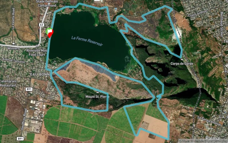
The trail begins at the La Ferme Reservoir wall and proceeds along the dam bank and vegetable gardens for 3km before climbing slowly at frst then more rapidly, up the Corps de Garde mountain, giving wonderful views of all Mauritius, until arriving at the summit. Then, the path plunges rapidly down over hyper-technical paths, not for the faint-hearted!, back down to the La Ferme lake, going along the emuddy edge and then climbing the pass between the Corps de Garde mountain and the Montagne St-Pierre through forest, then passing 4km oaver flat canefields, time to recover, then down the pass again, round the base of the St-Pierre mountain, then up to its summit at 550m, down through technical paths and round the base, through the Bambous village and back to the starting point.
Points of Interest table
| Accum. | Intermediary | |||||||
|---|---|---|---|---|---|---|---|---|
| POI | Description | Alt. | Dist. | D+ | D- | Dist. | D+ | D- |
 Competition organized on 11/17/2018
Trace n°50799
Ascent threshold : 3 m Distance threshold : 0 m Smoothing : No Origin of altitudes : GPS
Ascent threshold : 3 m Distance threshold : 0 m Smoothing : No Origin of altitudes : GPS
Loop
Dominant terrain : Footpath
Max alti. : 669 m
Avg alti. : 277 m
Min alti. : 112 m
Longest ascent : 510 m
Longest descent : 560 m
Dominant terrain : Footpath
Max alti. : 669 m
Avg alti. : 277 m
Min alti. : 112 m
Longest ascent : 510 m
Longest descent : 560 m
Elevation profile
More tools
Create a new roadbook page
Map and track on your website
Warning ! When you insert a Trace de Trail map on your website, you agree not to hide any element of the module (links to Trail Trail or Trail Connect banner)
Add a realisation
Validate
Add a realisation to share your chrono and describe the conditions that you encountered during you trail running !
Add a comment
Validate
Show the infos
Add a track


