Show the map
Certified Track - ITRA
Moka Trail 2018


 Inconnu (MU)


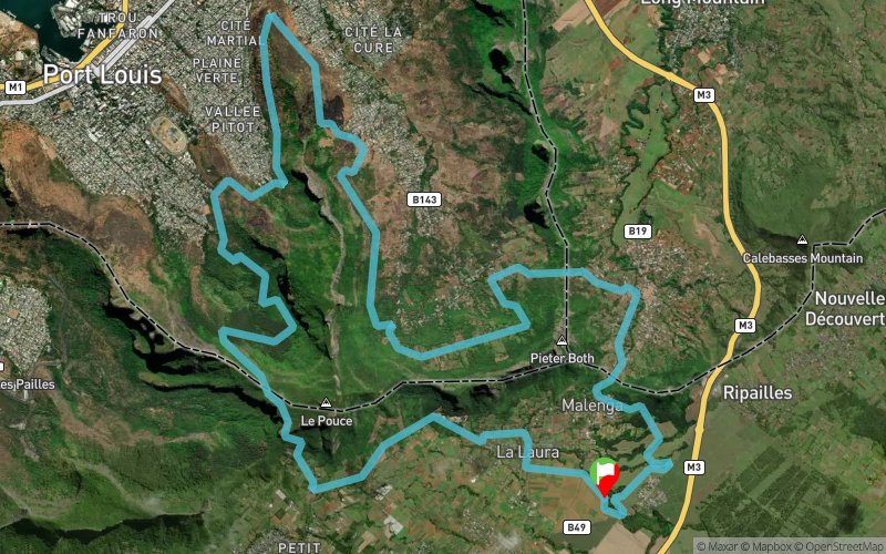
from the village of la laura. the runners will climbe ' Le Pouce ' on very technical single paths. they will then descend a very technical paths to the Dauguet parking. they will then run accros very technical paths with successive small uphills and downhills to reach valley des petre for the second refreshment point. after valley des pretes the will run arround the peter both to reach the village of creve coeur where they will run ona logn ascent road before climbing the 287 steps of the malinga steps. at the top the the malinga steps the runners will be able to refresh themselves before attacking the last 5km, to reach the finish line at la Laura
Points of Interest table
| Accum. | Intermediary | |||||||
|---|---|---|---|---|---|---|---|---|
| POI | Description | Alt. | Dist. | D+ | D- | Dist. | D+ | D- |
 Competition organized on 10/13/2018
Trace n°50260
Ascent threshold : 3 m Distance threshold : 0 m Smoothing : No Origin of altitudes : GPS
Ascent threshold : 3 m Distance threshold : 0 m Smoothing : No Origin of altitudes : GPS
Loop
Dominant terrain : Footpath
Max alti. : 609 m
Avg alti. : 291 m
Min alti. : 68 m
Longest ascent : 260 m
Longest descent : 350 m
Dominant terrain : Footpath
Max alti. : 609 m
Avg alti. : 291 m
Min alti. : 68 m
Longest ascent : 260 m
Longest descent : 350 m
Elevation profile
More tools
Create a new roadbook page
Map and track on your website
Warning ! When you insert a Trace de Trail map on your website, you agree not to hide any element of the module (links to Trail Trail or Trail Connect banner)
Add a realisation
Validate
Add a realisation to share your chrono and describe the conditions that you encountered during you trail running !
Add a comment
Validate
Show the infos
Add a track


