Show the map
Championnat de Maurice 2018


 Inconnu (MU)
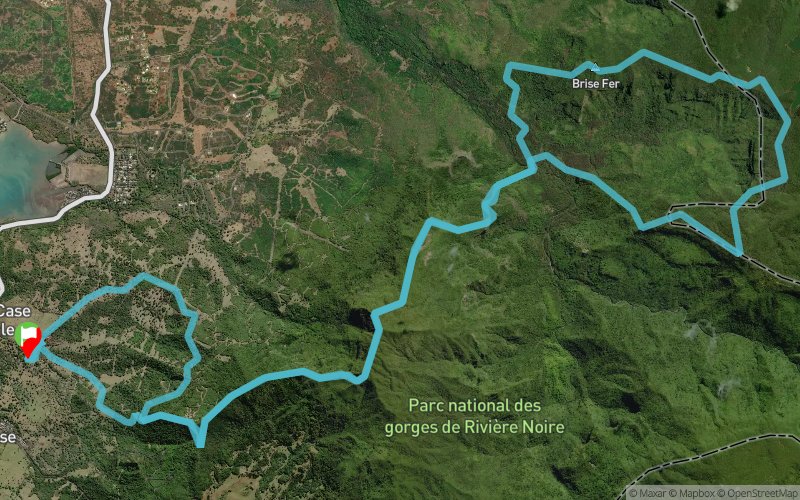
Start in the hunting grounds of Case Noyale at sea-level, a steady climb up to the highest point of Mauritius, Piton de la Riviere Noire, on singletrack paths, then down a very technical path to the Black River, then a loop on singletracks up and down extremely technical forest, and then back up the Piton Riviere Noire and back down to the start on different paths.
Points of Interest table
| Accum. | Intermediary | |||||||
|---|---|---|---|---|---|---|---|---|
| POI | Description | Alt. | Dist. | D+ | D- | Dist. | D+ | D- |
 Competition organized on 06/02/2018
Trace n°50255
Ascent threshold : 3 m Distance threshold : 0 m Smoothing : No Origin of altitudes : GPS
Ascent threshold : 3 m Distance threshold : 0 m Smoothing : No Origin of altitudes : GPS
Loop
Dominant terrain : Footpath
Max alti. : 812 m
Avg alti. : 432 m
Min alti. : -2 m
Longest ascent : 900 m
Longest descent : 900 m
Dominant terrain : Footpath
Max alti. : 812 m
Avg alti. : 432 m
Min alti. : -2 m
Longest ascent : 900 m
Longest descent : 900 m
Elevation profile
More tools
Create a new roadbook page
Map and track on your website
Warning ! When you insert a Trace de Trail map on your website, you agree not to hide any element of the module (links to Trail Trail or Trail Connect banner)
Add a realisation
Validate
Add a realisation to share your chrono and describe the conditions that you encountered during you trail running !
Add a comment
Validate
Show the infos
Add a track


