Show the map
Trail de Bize-Minervois 2018
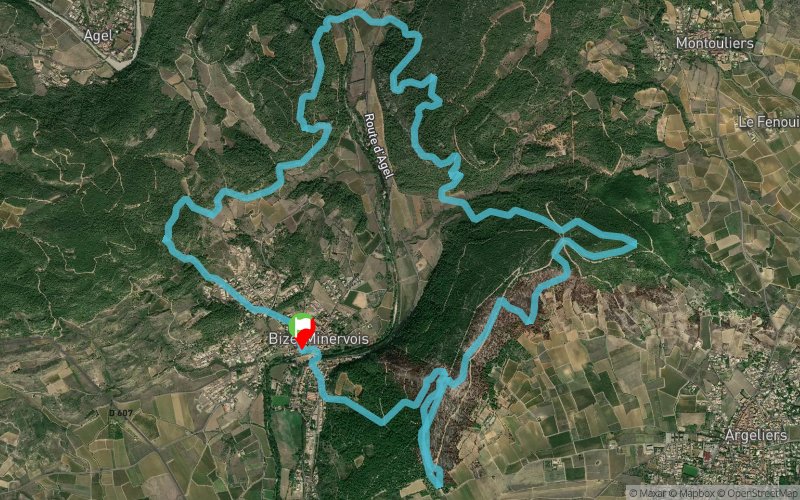


15.9 km
750 m
740 m
 Bize-Minervois (11)
 Points of Interest table
| Accum. | Intermediary | |||||||
|---|---|---|---|---|---|---|---|---|
| POI | Description | Alt. | Dist. | D+ | D- | Dist. | D+ | D- |
 Competition organized on 01/28/2018
Trace n°50166
Ascent threshold : 3 m Distance threshold : 30 m Smoothing : Yes Origin of altitudes : MNT Aster GDEM
Ascent threshold : 3 m Distance threshold : 30 m Smoothing : Yes Origin of altitudes : MNT Aster GDEM
Loop
Dominant terrain : Footpath
Max alti. : 214 m
Avg alti. : 131 m
Min alti. : 50 m
Longest ascent : 150 m
Longest descent : 160 m
Dominant terrain : Footpath
Max alti. : 214 m
Avg alti. : 131 m
Min alti. : 50 m
Longest ascent : 150 m
Longest descent : 160 m
Elevation profile
More tools
Create a new roadbook page
Map and track on your website
Warning ! When you insert a Trace de Trail map on your website, you agree not to hide any element of the module (links to Trail Trail or Trail Connect banner)
Add a realisation
Validate
Add a realisation to share your chrono and describe the conditions that you encountered during you trail running !
Add a comment
Validate
manuman
22/01/18, 21:11:54
YESSS. J'ai changé la route en trace avec Visualizer et elle est dans le gps. ;). Merci et a bientot
22/01/18, 21:11:54
YESSS. J'ai changé la route en trace avec Visualizer et elle est dans le gps. ;). Merci et a bientot
manuman
22/01/18, 20:04:05
en fait, il faut que je trouve un logiciel qui me change les "routes" en "trace" et normalement ca devrait aller
22/01/18, 20:04:05
en fait, il faut que je trouve un logiciel qui me change les "routes" en "trace" et normalement ca devrait aller
More comments
Show the infos
Add a track


