Show the map
Trail Urbain dans Rouen
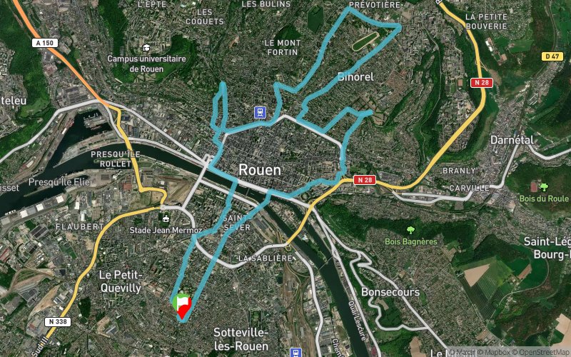


19.8 km
498 m
499 m
 Rouen (76)
 Points of Interest table
| Accum. | Intermediary | |||||||
|---|---|---|---|---|---|---|---|---|
| POI | Description | Alt. | Dist. | D+ | D- | Dist. | D+ | D- |
Trace n°4916
Ascent threshold : 0 m Distance threshold : 35 m Smoothing : Yes Origin of altitudes : MNT Aster GDEM
Ascent threshold : 0 m Distance threshold : 35 m Smoothing : Yes Origin of altitudes : MNT Aster GDEM
Loop
Dominant terrain : Road
Max alti. : 170 m
Avg alti. : 63 m
Min alti. : 4 m
Longest ascent : 163 m
Longest descent : 145 m
Route completed by the author : nc
Dominant terrain : Road
Max alti. : 170 m
Avg alti. : 63 m
Min alti. : 4 m
Longest ascent : 163 m
Longest descent : 145 m
Route completed by the author : nc
Elevation profile
More tools
Create a new roadbook page
Map and track on your website
Warning ! When you insert a Trace de Trail map on your website, you agree not to hide any element of the module (links to Trail Trail or Trail Connect banner)
Add a realisation
Validate
Add a realisation to share your chrono and describe the conditions that you encountered during you trail running !
Add a comment
Validate
Funkyjulio
23/11/14, 21:08:16
Parcours sympa surtout quand la nuit tombe tôt c'est éclairé partout.
23/11/14, 21:08:16
Parcours sympa surtout quand la nuit tombe tôt c'est éclairé partout.
Je n'ai fait que la parties avec les 3 côtes qui font bien chauffer les cuisses en partant de Saint sever.
Je laisserai une réalisation quand j'aurai fait le tour complet
Show the infos
Add a track


