Show the map
Evaluated Track - ITRA
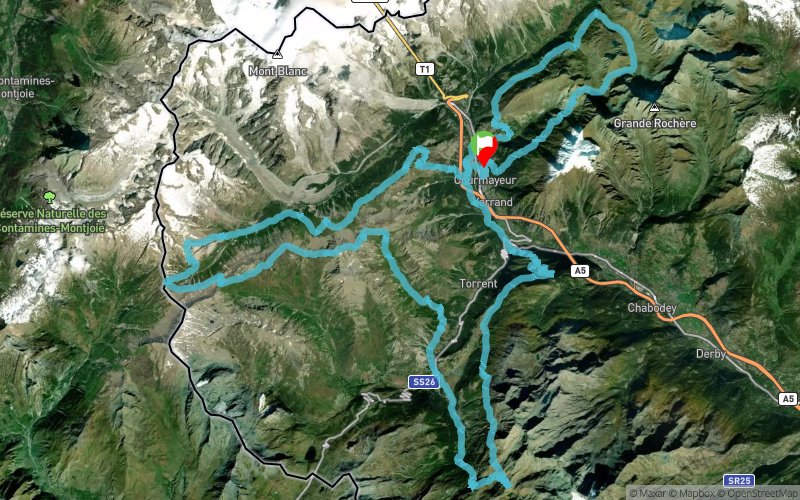
Gran Trail Courmayeur 2018 - GTC 105 km


 Courmayeur (IT)


The race goes through routes in Courmayeur, Pré-Saint-Didier and La Thuile for a total lenght of about 105km and an altitude range of 7000mt, mainly going along Val Veny and Val Ferret. The race is technical, due to the high altitude range but the routes it develops on are not particularly tricky. Passages on sealed roads are reduced to the minimum possibile: the race will use them just around town where it crosses public streets.
Points of Interest table
| Accum. | Intermediary | |||||||
|---|---|---|---|---|---|---|---|---|
| POI | Description | Alt. | Dist. | D+ | D- | Dist. | D+ | D- |
 Competition organized on 07/14/2018
Trace n°48057
Ascent threshold : 3 m Distance threshold : 30 m Smoothing : Yes Origin of altitudes : MNT Google
Ascent threshold : 3 m Distance threshold : 30 m Smoothing : Yes Origin of altitudes : MNT Google
Loop
Dominant terrain : Footpath
Max alti. : 2860 m
Avg alti. : 1972 m
Min alti. : 1016 m
Longest ascent : 1800 m
Longest descent : 1300 m
Dominant terrain : Footpath
Max alti. : 2860 m
Avg alti. : 1972 m
Min alti. : 1016 m
Longest ascent : 1800 m
Longest descent : 1300 m
More tools
Create a new roadbook page
Map and track on your website
Warning ! When you insert a Trace de Trail map on your website, you agree not to hide any element of the module (links to Trail Trail or Trail Connect banner)
Add a realisation
Validate
Add a realisation to share your chrono and describe the conditions that you encountered during you trail running !
Add a comment
Validate
Show the infos
Add a track


