Show the map
St-Martin-du-Tartre - Bissy-sur-Fley
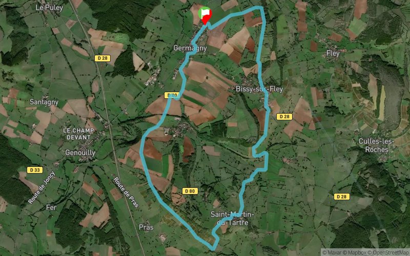


14.13 km
330 m
330 m
 Germagny (71)
 Points of Interest table
| Accum. | Intermediary | |||||||
|---|---|---|---|---|---|---|---|---|
| POI | Description | Alt. | Dist. | D+ | D- | Dist. | D+ | D- |
Trace n°4438
Ascent threshold : 0 m Distance threshold : 30 m Smoothing : Yes Origin of altitudes : MNT IGN
Ascent threshold : 0 m Distance threshold : 30 m Smoothing : Yes Origin of altitudes : MNT IGN
Loop
Dominant terrain : Path
Max alti. : 436 m
Avg alti. : 339 m
Min alti. : 252 m
Longest ascent : 210 m
Longest descent : 140 m
Route completed by the author : Yes
Dominant terrain : Path
Max alti. : 436 m
Avg alti. : 339 m
Min alti. : 252 m
Longest ascent : 210 m
Longest descent : 140 m
Route completed by the author : Yes
Elevation profile
More tools
Create a new roadbook page
Map and track on your website
Warning ! When you insert a Trace de Trail map on your website, you agree not to hide any element of the module (links to Trail Trail or Trail Connect banner)
Add a realisation
Validate
Add a realisation to share your chrono and describe the conditions that you encountered during you trail running !
Add a comment
Validate
cerveau-de-hamster
31/12/14, 09:06:55
De voyage dans la région de St Martin du Tartre : Merci pour la trace que j'ai faite Dimanche 28 et refaite Lundi 29 tellement elle était bien. Il fait frais avec la neige et le vent.
31/12/14, 09:06:55
De voyage dans la région de St Martin du Tartre : Merci pour la trace que j'ai faite Dimanche 28 et refaite Lundi 29 tellement elle était bien. Il fait frais avec la neige et le vent.
Show the infos
Add a track


