Show the map
Vignec - Soulan - Granges de Camplets
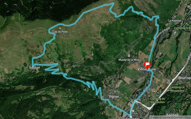


13.3 km
860 m
870 m
 Vielle-Aure (65)
 Vielle-Aure (65)
 Points of Interest table
| Accum. | Intermediary | |||||||
|---|---|---|---|---|---|---|---|---|
| POI | Description | Alt. | Dist. | D+ | D- | Dist. | D+ | D- |
Trace n°42514
Ascent threshold : 3 m Distance threshold : 30 m Smoothing : Yes Origin of altitudes : MNT Aster GDEM
Ascent threshold : 3 m Distance threshold : 30 m Smoothing : Yes Origin of altitudes : MNT Aster GDEM
Loop
Dominant terrain : Path
Max alti. : 1633 m
Avg alti. : 1156 m
Min alti. : 782 m
Longest ascent : 860 m
Longest descent : 860 m
Route completed by the author : nc
Dominant terrain : Path
Max alti. : 1633 m
Avg alti. : 1156 m
Min alti. : 782 m
Longest ascent : 860 m
Longest descent : 860 m
Route completed by the author : nc
Elevation profile
More tools
Create a new roadbook page
Map and track on your website
Warning ! When you insert a Trace de Trail map on your website, you agree not to hide any element of the module (links to Trail Trail or Trail Connect banner)
Add a realisation
Validate
Add a realisation to share your chrono and describe the conditions that you encountered during you trail running !
Add a comment
Validate
lvr123
25/07/18, 11:02:02
Le debut de la descente vers Vieille Aure, aux alentours de la crête de Grascouéou n'est bien balisée. Il faut viser les granges en contrebas. Au départ, à la sortie de Vignec, préférer le 2ème sentier à gauche plutôt que la route. Ce sont les balises jaunes.
25/07/18, 11:02:02
Le debut de la descente vers Vieille Aure, aux alentours de la crête de Grascouéou n'est bien balisée. Il faut viser les granges en contrebas. Au départ, à la sortie de Vignec, préférer le 2ème sentier à gauche plutôt que la route. Ce sont les balises jaunes.
Show the infos
Add a track


