Show the map
Campagnette - Bois d'Esquerdes - Bois d'Elnes
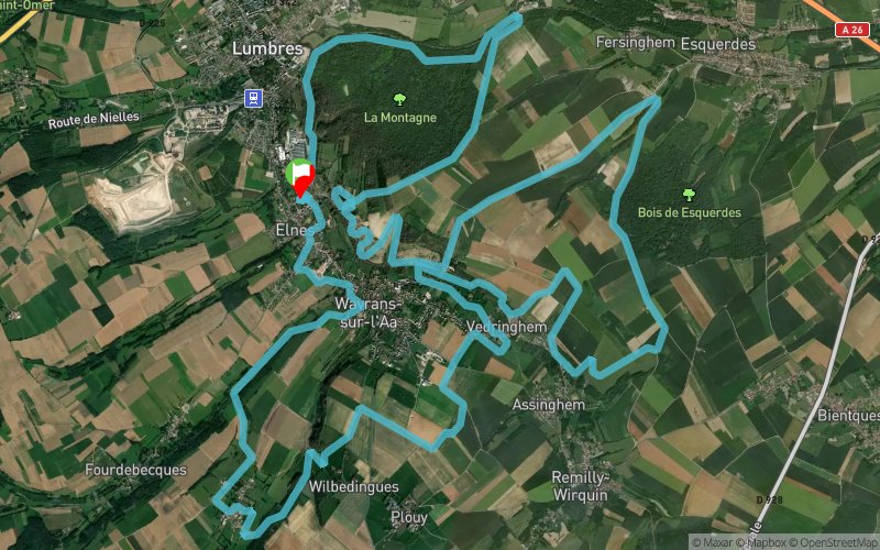


32.5 km
1020 m
1020 m
 Elnes (62)
 Points of Interest table
| Accum. | Intermediary | |||||||
|---|---|---|---|---|---|---|---|---|
| POI | Description | Alt. | Dist. | D+ | D- | Dist. | D+ | D- |
Trace n°38797
Ascent threshold : 10 m Distance threshold : 30 m Smoothing : Yes Origin of altitudes : MNT Aster GDEM
Ascent threshold : 10 m Distance threshold : 30 m Smoothing : Yes Origin of altitudes : MNT Aster GDEM
Loop
Dominant terrain : Footpath
Max alti. : 160 m
Avg alti. : 77 m
Min alti. : 29 m
Longest ascent : 100 m
Longest descent : 90 m
Route completed by the author : nc
Dominant terrain : Footpath
Max alti. : 160 m
Avg alti. : 77 m
Min alti. : 29 m
Longest ascent : 100 m
Longest descent : 90 m
Route completed by the author : nc
Elevation profile
More tools
Create a new roadbook page
Map and track on your website
Warning ! When you insert a Trace de Trail map on your website, you agree not to hide any element of the module (links to Trail Trail or Trail Connect banner)
Add a realisation
Validate
Add a realisation to share your chrono and describe the conditions that you encountered during you trail running !
Add a comment
Validate
traildescoteauxdelaa
21/11/18, 15:37:07
Il y a beaucoup de passage interdit ( parcelles privées) sur ce parcours
21/11/18, 15:37:07
Il y a beaucoup de passage interdit ( parcelles privées) sur ce parcours
Show the infos
Add a track


