
Mark Twain Endurance Runs 2017
ITRA
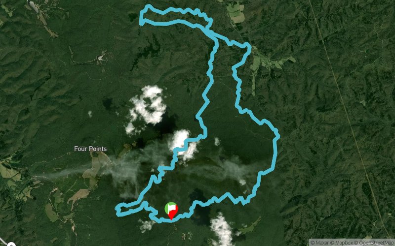
 161.8 km
2300 m
2300 m
161.8 km
2300 m
2300 m

GPX
21
PDF
Profile
Share
3D
Favorites
Reviews
Like
Potosi (US) (US)
Effort kilometer
Longest ascent
Longest descent
184
90 m
80 m
Max. elevation
Min. elevation
Quality index
369 m
257 m
 1pt/11m
Race Basics & Details
“There are basically two types of people. People who accomplish things and people who claim to have accomplished things. The first group is less crowded.” - Mark Twain
Location: Berryman Campground - Berryman, MO
Start Date/Time: Saturday September 16, 2017 6:00am CDT
Distance: 50 Mile Run (2 x 25 mile loop) * 100 Mile Run (4 x 25 mile loop)
Elevation: 2,500/ft.of ascent/descent per 25 Mile Loop * 5,000/ft. gain/loss for 50 Mile Run * 10,000/ft. for 100 Mile Run
Time Limit: 50 Mile Run -16 hours * 100 Mile Run - 32 hours
Aid Stations: 5 manned including 2 drop bag locations with crew access per loop
Pacers: 100 Mile Runners can use a pacer starting with their 3rd loop (50 Miles) through the finish
Finisher Awards: 50 Mile Run- Distance Medal * 100 Mile Run- Belt Buckles * Two-Tone Buckle for sub-24 hours
Special Awards: 100 and 50 Mile Female/Male Winners - Mark Twain Marble Statue
The Mark Twain Endurance Runs, presented by the Saint Louis Ultrarunners Group, are in their 6th year. We provide excellent aid and a great venue with generous time limits to provide both the most veteran of runners and first timers a great experience.
The course is a 99% single track trail race with held in the Mark Twain National Forest outside Berryman, MO on the Berryman Trail located about 1.5 hours from St. Louis, MO. The Berryman Trail is a 25+ mile loop that will be repeated 2 (50 Mile Run) or 4 times (100 Mile Run) counterclockwise. Each loop starts and stops in the Berryman Campground where you and your crew/family are welcome to stay and camp at no cost.
The Berryman Trail traverses many Ozark hills and features long, sustained climbs and fast, rocky descents. The trail is customarily divided into 2 parts; the western 14+ mile section between Berryman Campground trailhead and the Brazil Creek Campground trailhead, and the eastern 10+ miles from Brazil Creek back to the Berryman Campground which completes the loop. The Ozark Trail makes use of the western part of the loop from where it joins it at Harmon Spring, to just west of the Berryman Campground. The Brazil Creek to Berryman Campground section has numerous climbs and descents, none of them really steep, which cross several valleys. This section is also quite rocky with many exposed roots. The western section, while longer, generally contains less climbing, but isn't necessarily easier.
The 2016 Mark Twain Endurance Runs provided much excitement with our 100 Mile F1 Jennifer Rolfing take the lead in the final miles of the race. Our 100 Mile M1 Jason Wagner outpaced the 3 other runners who were equal with him after the second loop. We hope you will join us in September to help us write another great story!
Mark Twain Endurance Runs participates in the Trail Runner Trophy Series.
Additionally, Mark Twain Endurance Runs 100 Mile will be a UTMB/CCC Points Qualifier for 2018 as it was for 2017.
Nearly Live Runner Tracking: Via Twitter @mter100_50
Schedule:
Friday 9/15/17 * 5-7pm- Pre-Race Meal and Race Briefing at Huzzah Valley Resort
Saturday 9/16/17 * 6am- 50 and 100 Mile Run Start * 10pm- 50 Mile Run Ends
Sunday, 9/17/17 * 2pm- 100 Mile Run Ends
Training Run/Course Preview: TBA in August 2017
Entry Fees and Policy
50 Mile Run- $90 before January 1st, 2017, $110 January 1st – August 31st, 2017, $130 after September 1st, 2017.
100 Mile Run- $165 before January 1st, 2017, $190 January 1st – August 31st, 2017, $215 after September 1st, 2017.
There are no refunds or bib transfers. There will not be any rollovers to next year’s race. Drop downs allowed if Race Director is notified before the start of the Runs. No guarantee on swag or finishers medals to registrations made after August 31, 2017.
En voir plus... En voir moins...

Start
Distance
0 km
Altitude
317 m
D+
0 m
D-
0 m
161.8 km
2300 m
2300 m
Finish
Distance
161.8 km
Altitude
317 m
D+
2300 m
D-
2300 m
Click on a point of interest to display it on the map
Reviews and times
Add a track
Mark Twain Endurance Runs 2017

Track number : 35064
Link to track :
https://tracedetrail.fr/en/trace/35064
Log in to insert this track on your website
 Trace de Trail