Show the map
OFFICIAL ROUTE
Trail des Cagous 2017 - Foulées Kalenji
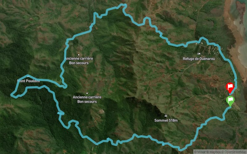


20.4 km
860 m
870 m
 Yaté (NC)
 Yaté (NC)
 5
5 270
270 Points of Interest table
| Accum. | Intermediary | |||||||
|---|---|---|---|---|---|---|---|---|
| POI | Description | Alt. | Dist. | D+ | D- | Dist. | D+ | D- |
 Competition organized on 04/02/2017
Trace n°34331
Ascent threshold : 10 m Distance threshold : 0 m Smoothing : No Origin of altitudes : GPS + MNT Aster GDEM
Ascent threshold : 10 m Distance threshold : 0 m Smoothing : No Origin of altitudes : GPS + MNT Aster GDEM
Loop
Dominant terrain : Footpath
Max alti. : 518 m
Avg alti. : 290 m
Min alti. : 150 m
Longest ascent : 340 m
Longest descent : 340 m
Dominant terrain : Footpath
Max alti. : 518 m
Avg alti. : 290 m
Min alti. : 150 m
Longest ascent : 340 m
Longest descent : 340 m
Elevation profile
More tools
Create a new roadbook page
Map and track on your website
Warning ! When you insert a Trace de Trail map on your website, you agree not to hide any element of the module (links to Trail Trail or Trail Connect banner)
Add a realisation
Validate
Add a realisation to share your chrono and describe the conditions that you encountered during you trail running !
Add a comment
Validate
NCAventure
15/03/17, 06:09:37
Pouvez vous m'expliquer la procédure ? Il me semblait avoir tout bien fait dans l'ordre. Merci
15/03/17, 06:09:37
Pouvez vous m'expliquer la procédure ? Il me semblait avoir tout bien fait dans l'ordre. Merci
Admin - Trace de Trail
14/03/17, 21:49:10
Bonjour, Merci de préciser le nom de votre compétition avant de la placer en publique.
14/03/17, 21:49:10
Bonjour, Merci de préciser le nom de votre compétition avant de la placer en publique.
Show the infos
Add a track


