Show the map
Combe des Arles - Col du Lac - La Done
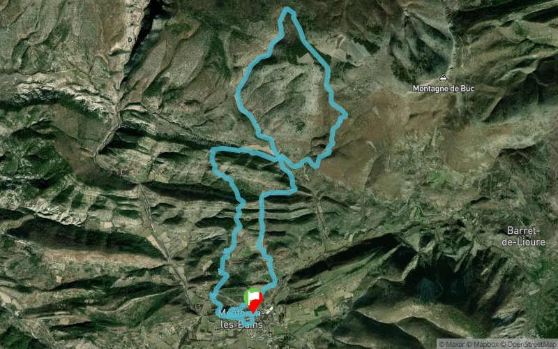


15.6 km
700 m
700 m
 Montbrun-les-Bains (26)
 Points of Interest table
| Accum. | Intermediary | |||||||
|---|---|---|---|---|---|---|---|---|
| POI | Description | Alt. | Dist. | D+ | D- | Dist. | D+ | D- |
Trace n°29652
Ascent threshold : 1 m Distance threshold : 30 m Smoothing : Yes Origin of altitudes : MNT Aster GDEM
Ascent threshold : 1 m Distance threshold : 30 m Smoothing : Yes Origin of altitudes : MNT Aster GDEM
Loop
Dominant terrain : Footpath
Max alti. : 1100 m
Avg alti. : 792 m
Min alti. : 591 m
Longest ascent : 370 m
Longest descent : 570 m
Route completed by the author : nc
Dominant terrain : Footpath
Max alti. : 1100 m
Avg alti. : 792 m
Min alti. : 591 m
Longest ascent : 370 m
Longest descent : 570 m
Route completed by the author : nc
Elevation profile
More tools
Create a new roadbook page
Map and track on your website
Warning ! When you insert a Trace de Trail map on your website, you agree not to hide any element of the module (links to Trail Trail or Trail Connect banner)
Add a realisation
Validate
Add a realisation to share your chrono and describe the conditions that you encountered during you trail running !
Add a comment
Validate
claudechappon
23/11/16, 15:42:54
Venez découvrir ce parcours avec une vue imprenable sur le Mont Ventoux et un passage à la Chapelle de la Donne, endroit magnifique et magique........
23/11/16, 15:42:54
Venez découvrir ce parcours avec une vue imprenable sur le Mont Ventoux et un passage à la Chapelle de la Donne, endroit magnifique et magique........
Show the infos
Add a track


