Show the map
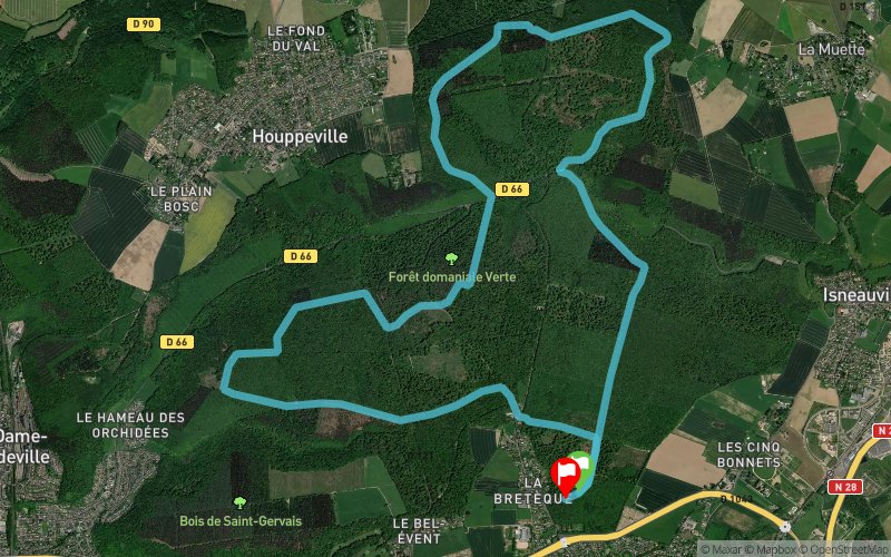
La Butte - Les Cotrets - Le Haut Bosc - Grand Canton


14.7 km
340 m
340 m


Points of Interest table
Accum. | Intermediary | |||||||
---|---|---|---|---|---|---|---|---|
POI | Description | Alt. | Dist. | D+ | D- | Dist. | D+ | D- |
Trace n°29541
Ascent threshold : 3 m Distance threshold : 30 m Smoothing : Yes Origin of altitudes : MNT Aster GDEM
Loop
Dominant terrain : Path
Max alti. : 187 m
Avg alti. : 151 m
Min alti. : 87 m
Longest ascent : 100 m
Longest descent : 90 m
Route completed by the author : nc
Dominant terrain : Path
Max alti. : 187 m
Avg alti. : 151 m
Min alti. : 87 m
Longest ascent : 100 m
Longest descent : 90 m
Route completed by the author : nc
Elevation profile

Their last tracks
Serra del Franc - Monserrat - Serra Llarga - Monestir de Montserrat
23.5 km
1940 m
1940 m
Marganell (ES)
Côte Ste-Catherine - Bonsecours - Bois du Roule - Darnétal - St-Exupéry
14.4 km
500 m
500 m
Rouen (76)
More tools
Create a new roadbook page
Carte à la Carte IGN
Map and track on your website
Warning ! When you insert a Trace de Trail map on your website, you agree not to hide any element of the module (links to Trail Trail or Trail Connect banner)
Add a realisation
Validate
Add a realisation to share your chrono and describe the conditions that you encountered during you trail running !
Add a comment
Validate
Nearby tracks
0.2 km Les Ventes de Bas - Houppeville - Chemin du Haut Bosc
21.1 km
400 m
410 m
Mont-Saint-Aignan (76)
1.7 km Le Grand Canton - Les Cotrets - Le Haut Bosc - Bois de St-Gervais
36.9 km
1040 m
1060 m
Mont-Saint-Aignan (76)
1.7 km Le Grand Canton - Les Cotrets - Bois de la Côte d'Isneauville
17.9 km
400 m
400 m
Mont-Saint-Aignan (76)
5.7 km Forêt verte départ Notre-Dame-de-Bondeville
11.3 km
320 m
327 m
Notre-Dame-de-Bondeville (76)
7.9 km Côte Ste-Catherine - Bonsecours - Bois du Roule - Darnétal - St-Exupéry
14.4 km
500 m
500 m
Rouen (76)
8.6 km Forêt de Roumare - Bois de la Fontaine - Duclair - St-Wandrille-Rançon
43.7 km
1400 m
1380 m
Rouen (76)
Show the infos
Add a track