Show the map
Trail d'Aramon 2016
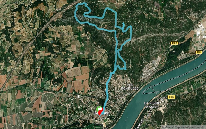


13.4 km
280 m
290 m
 Aramon (30)
Points of Interest table
| Accum. | Intermediary | |||||||
|---|---|---|---|---|---|---|---|---|
| POI | Description | Alt. | Dist. | D+ | D- | Dist. | D+ | D- |
 Competition organized on 10/01/2016
Trace n°28333
Ascent threshold : 3 m Distance threshold : 30 m Smoothing : Yes Origin of altitudes : MNT Aster GDEM
Ascent threshold : 3 m Distance threshold : 30 m Smoothing : Yes Origin of altitudes : MNT Aster GDEM
Loop
Dominant terrain : Footpath
Max alti. : 130 m
Avg alti. : 75 m
Min alti. : 12 m
Longest ascent : 80 m
Longest descent : 90 m
Dominant terrain : Footpath
Max alti. : 130 m
Avg alti. : 75 m
Min alti. : 12 m
Longest ascent : 80 m
Longest descent : 90 m
Elevation profile
More tools
Create a new roadbook page
Map and track on your website
Warning ! When you insert a Trace de Trail map on your website, you agree not to hide any element of the module (links to Trail Trail or Trail Connect banner)
Add a realisation
Validate
Add a realisation to share your chrono and describe the conditions that you encountered during you trail running !
Add a comment
Validate
Admin - Trace de Trail
25/10/16, 21:57:56
Bonjour, Merci de classer votre trace en compétition avant de la placer en publique.
25/10/16, 21:57:56
Bonjour, Merci de classer votre trace en compétition avant de la placer en publique.
Show the infos
Add a track


