Show the map
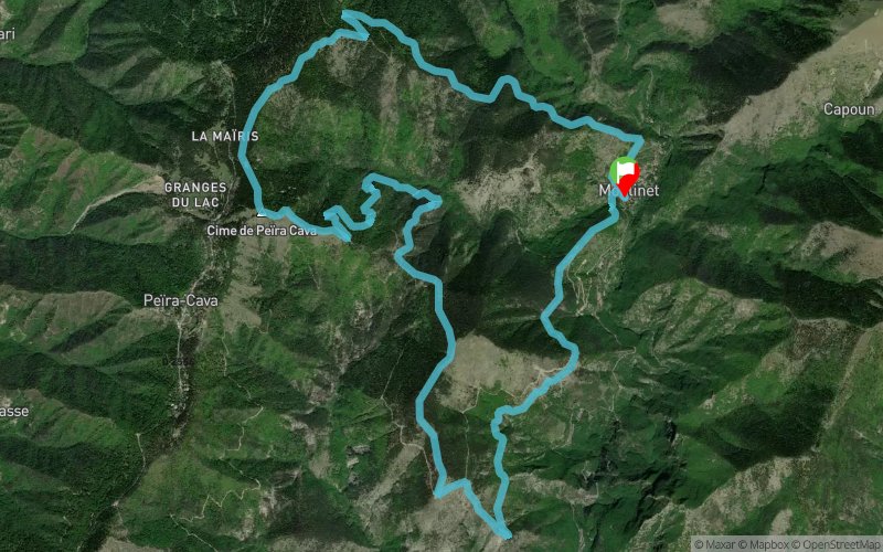
trail du moulinet (21 km 1200 den+)


20.3 km
1817 m
1820 m

Points of Interest table
Accum. | Intermediary | |||||||
---|---|---|---|---|---|---|---|---|
POI | Description | Alt. | Dist. | D+ | D- | Dist. | D+ | D- |

Trace n°2592
Ascent threshold : 0 m Distance threshold : 35 m Smoothing : Yes Origin of altitudes : MNT Aster GDEM
Loop
Dominant terrain : Footpath
Max alti. : 1632 m
Avg alti. : 1227 m
Min alti. : 789 m
Longest ascent : 598 m
Longest descent : 711 m
Dominant terrain : Footpath
Max alti. : 1632 m
Avg alti. : 1227 m
Min alti. : 789 m
Longest ascent : 598 m
Longest descent : 711 m
Elevation profile

Their last tracks
More tools
Create a new roadbook page
Carte à la Carte IGN
Map and track on your website
Warning ! When you insert a Trace de Trail map on your website, you agree not to hide any element of the module (links to Trail Trail or Trail Connect banner)
Add a realisation
Validate
Add a realisation to share your chrono and describe the conditions that you encountered during you trail running !
Add a comment
Validate
Nearby tracks
5.2 km Forêt de Lantosque - Pas de la Capelette - Beccas - Crête de Mandine
29.5 km
1520 m
1520 m
Moulinet (06)
6.2 km Col de Turini - Lacs du Diable - Ref. des Merveilles - Ref. de Nice - Le Boréon
44.4 km
3670 m
3750 m
Moulinet (06)
7.5 km Baisse de Camp d'Argent - Lacs du Diable - Baisse du Basto - Pas des Ladres
39 km
2790 m
3010 m
Moulinet (06)
9.5 km Pointe des 3 Communes - Ref. des Merveilles - Lac Autier - Ref. de Nice - Pas de l'Arpette
45.9 km
3330 m
3340 m
Moulinet (06)
9.5 km Pointe des 3 Communes - Cime du Diable - Ref. de Nice - Pas du Diable
45.9 km
3326 m
3333 m
Moulinet (06)
10.4 km Col du Pérus - Col de Brouis - Breil-sur-Roya - Saorge - Baisse d'Anon
46.5 km
3730 m
3340 m
Sospel (06)
Show the infos
Add a track