Show the map
Certified Track - ITRA
Vryseada 2016


 Sparti (GR)


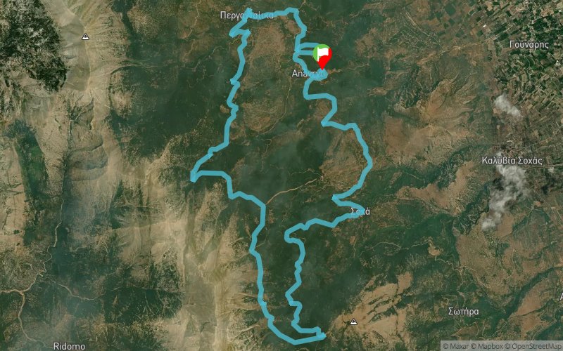
A 30km trail run on Taygetos mountain, with 1635m positive elevation and no supply points. The major part of its route crosses the european path E4. The race starts and finishes in the village of Anavryti.
The race was inspired by the ancient day-runners, that run over the Greek mountains, to deliver important messages. The participants, following their footsteps, will have to complete the race self sufficiently.
Points of Interest table
| Accum. | Intermediary | |||||||
|---|---|---|---|---|---|---|---|---|
| POI | Description | Alt. | Dist. | D+ | D- | Dist. | D+ | D- |
 Competition organized on 09/11/2016
Trace n°25097
Ascent threshold : 10 m Distance threshold : 0 m Smoothing : No Origin of altitudes : GPS + MNT Aster GDEM
Ascent threshold : 10 m Distance threshold : 0 m Smoothing : No Origin of altitudes : GPS + MNT Aster GDEM
Loop
Dominant terrain : Footpath
Max alti. : 1478 m
Avg alti. : 1088 m
Min alti. : 747 m
Longest ascent : 420 m
Longest descent : 450 m
Dominant terrain : Footpath
Max alti. : 1478 m
Avg alti. : 1088 m
Min alti. : 747 m
Longest ascent : 420 m
Longest descent : 450 m
Elevation profile
More tools
Create a new roadbook page
Map and track on your website
Warning ! When you insert a Trace de Trail map on your website, you agree not to hide any element of the module (links to Trail Trail or Trail Connect banner)
Add a realisation
Validate
Add a realisation to share your chrono and describe the conditions that you encountered during you trail running !
Add a comment
Validate
Show the infos
Add a track


