
Rando trail - n°1 Vert - Tour des Pistes
 6.5 km
271 m
270 m
6.5 km
271 m
270 m
GPX
82
PDF
Profile
Share
3D
Favorites
Reviews
1 Like
Gérardmer (88) Gérardmer (88)
Effort kilometer
Longest ascent
Longest descent
9
261 m
226 m
Max. elevation
Min. elevation
Quality index
1110 m
854 m
 1pt/29m
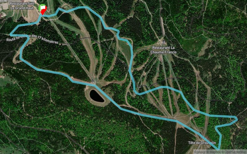
Montée progressive à travers le Domaine skiable jusqu’à la Tête de Grouvelin (sommet des pistes et panorama sur le Massif des Vosges) puis retour à la Mauselaine (base départ-arrivée) via la Tête de la Chaume Francis et le Grand Haut
Track created by Admin - Trace de Trail
le 2014/03/31 (modified on 2015/07/23)
le 2014/03/31 (modified on 2015/07/23)


Start
Distance
0 km
Altitude
859 m
D+
0 m
D-
0 m
3.5 km
257 m
7 m
Tête de Grouvelin (alt.1137m)
Distance
3.5 km
Altitude
1107 m
D+
257 m
D-
7 m
1.2 km
14 m
40 m
Le Grand Haut
Distance
4.7 km
Altitude
1079 m
D+
271 m
D-
47 m
1.7 km
0 m
223 m
Finish
Distance
6.5 km
Altitude
859 m
D+
271 m
D-
270 m
Click on a point of interest to display it on the map
Reviews and times
gonsette1642015/07/20
2015/07/19 00:55:00
2015/07/19 00:55:00
Ascension sympathique entre les pistes et la foret. Tres belle vue au Grouvelin. Descente par piste bleu par très agréable pour les genoux (surtout par temps humide)
NB: travaux après la tête de Grouvelin.
Add a track
Rando trail - n°1 Vert - Tour des Pistes

Track number : 2328
Link to track :
https://tracedetrail.fr/en/trace/2328
Log in to insert this track on your website
 Trace de Trail