Show the map
Certified Track - ITRA
Trainic-World In Sotochichibu 2016 - 50Km
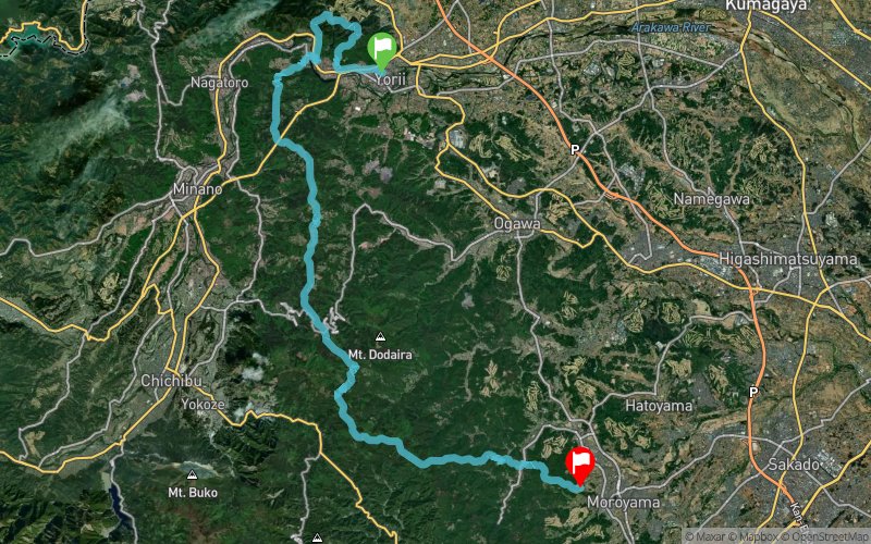


 Yorii (JP)
 Takinoiri (JP)


Yorii to Ogose. Course which runs a mountain range that spans Oku-Musashi Oku from Higashi-Chichibu.
Points of Interest table
| Accum. | Intermediary | |||||||
|---|---|---|---|---|---|---|---|---|
| POI | Description | Alt. | Dist. | D+ | D- | Dist. | D+ | D- |
 Competition organized on 05/08/2016
Trace n°22088
Ascent threshold : 10 m Distance threshold : 0 m Smoothing : No Origin of altitudes : GPS + MNT Aster GDEM
Ascent threshold : 10 m Distance threshold : 0 m Smoothing : No Origin of altitudes : GPS + MNT Aster GDEM
Crossing
Dominant terrain : Path
Max alti. : 849 m
Avg alti. : 445 m
Min alti. : 63 m
Longest ascent : 400 m
Longest descent : 730 m
Dominant terrain : Path
Max alti. : 849 m
Avg alti. : 445 m
Min alti. : 63 m
Longest ascent : 400 m
Longest descent : 730 m
Elevation profile
More tools
Create a new roadbook page
Map and track on your website
Warning ! When you insert a Trace de Trail map on your website, you agree not to hide any element of the module (links to Trail Trail or Trail Connect banner)
Add a realisation
Validate
Add a realisation to share your chrono and describe the conditions that you encountered during you trail running !
Add a comment
Validate
Show the infos
Add a track


