Show the map
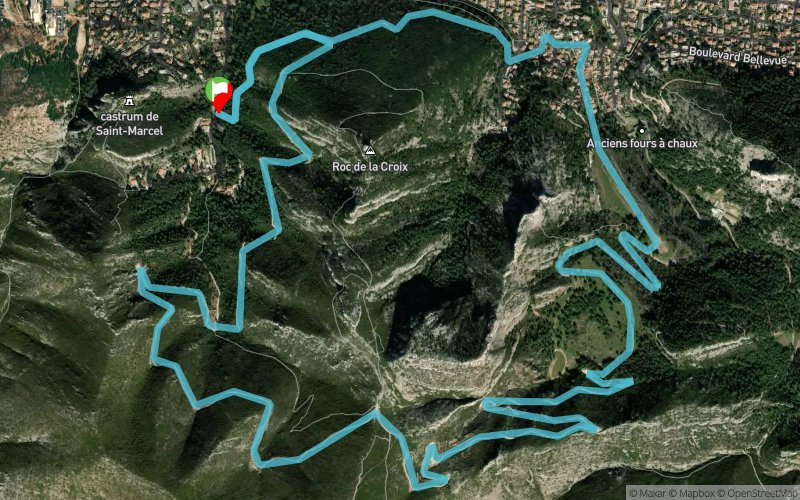
Vallon de la Vigie - Col Galvaudan

Points of Interest table
Accum. | Intermediary | |||||||
---|---|---|---|---|---|---|---|---|
POI | Description | Alt. | Dist. | D+ | D- | Dist. | D+ | D- |
Trace n°19122
Ascent threshold : 3 m Distance threshold : 30 m Smoothing : Yes Origin of altitudes : MNT Aster GDEM
Loop
Dominant terrain : Path
Max alti. : 357 m
Avg alti. : 198 m
Min alti. : 75 m
Longest ascent : 250 m
Longest descent : 130 m
Route completed by the author : nc
Dominant terrain : Path
Max alti. : 357 m
Avg alti. : 198 m
Min alti. : 75 m
Longest ascent : 250 m
Longest descent : 130 m
Route completed by the author : nc
Elevation profile

More tools
Create a new roadbook page
Carte à la Carte IGN
Map and track on your website
Warning ! When you insert a Trace de Trail map on your website, you agree not to hide any element of the module (links to Trail Trail or Trail Connect banner)
Add a realisation
Validate
Add a realisation to share your chrono and describe the conditions that you encountered during you trail running !
Add a comment
Validate
Nearby tracks
0.3 km St-Marcel - Col Galvaudan - Source des Eaux Vives - Mont St-Cyr
9.5 km
530 m
540 m
Marseille 11 (13)
1.2 km Col Galvaudan - Mont Carpiagne - Mont Lantin - Vallon de la Barasse
13.9 km
810 m
800 m
La Penne-sur-Huveaune (13)
1.2 km Mont Carpiagne - Mont Lantin - La Penne-sur-Huveaune
18.6 km
1130 m
1130 m
La Penne-sur-Huveaune (13)
3.1 km Mont St-Cyr - Col Galvaudan - Col Sabatier - Vallon de l'Évêque
12.5 km
810 m
800 m
Marseille 11 (13)
3.1 km Parc des Bruyères - Mont Carpiagne - Col de la Gineste - Col de l'Oule - Port Miou
19.1 km
1270 m
1330 m
Marseille 11 (13)
6.1 km Allauch - Pic du Taoumé - Le Garlaban - Les Trois Lucs
32.6 km
1130 m
1120 m
Marseille 04 (13)
6.3 km Le Redon - Col de Mergiou - Col de la Candelle - Col de Sugiton
23.6 km
1280 m
1280 m
Marseille 09 (13)
Show the infos
Add a track