
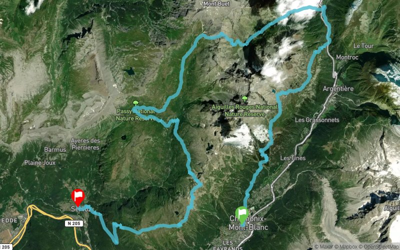
Trail des Aiguilles Rouges 2014
 50.3 km
3830 m
4059 m
50.3 km
3830 m
4059 m

28/09/2014
GPX
101
PDF
Profile
Share
3D
Favorites
Reviews
Like
Chamonix-Mont-Blanc (74) Servoz (74)
Effort kilometer
Longest ascent
Longest descent
88
1388 m
1448 m
Max. elevation
Min. elevation
Quality index
2509 m
812 m
 1pt/42m
Track created by Trail des Aiguilles Rouges
le 2014/02/03 (modified on 2014/09/21)
le 2014/02/03 (modified on 2014/09/21)


Start
Distance
0 km
Altitude
1039 m
D+
0 m
D-
0 m
15.6 km
1394 m
1096 m
Village du Buet
Distance
15.6 km
Altitude
1337 m
D+
1394 m
D-
1096 m
14.6 km
1421 m
784 m
Refuge de Moëde-Anterne
Distance
30.3 km
Altitude
1979 m
D+
2815 m
D-
1880 m
8.8 km
882 m
459 m
Le Brévent
Distance
39.1 km
Altitude
2405 m
D+
3697 m
D-
2339 m
3.9 km
130 m
282 m
Aiguillette des Houches
Distance
43 km
Altitude
2253 m
D+
3827 m
D-
2621 m
7.2 km
3 m
1438 m
Finish
Distance
50.3 km
Altitude
812 m
D+
3830 m
D-
4059 m
Click on a point of interest to display it on the map
Reviews and times
Add a track
Trail des Aiguilles Rouges 2014

Track number : 1763
Link to track :
https://tracedetrail.fr/en/trace/1763
Log in to insert this track on your website
 Trace de Trail