Show the map
Montberon - Bois du Moureau - Le Clos de Barat
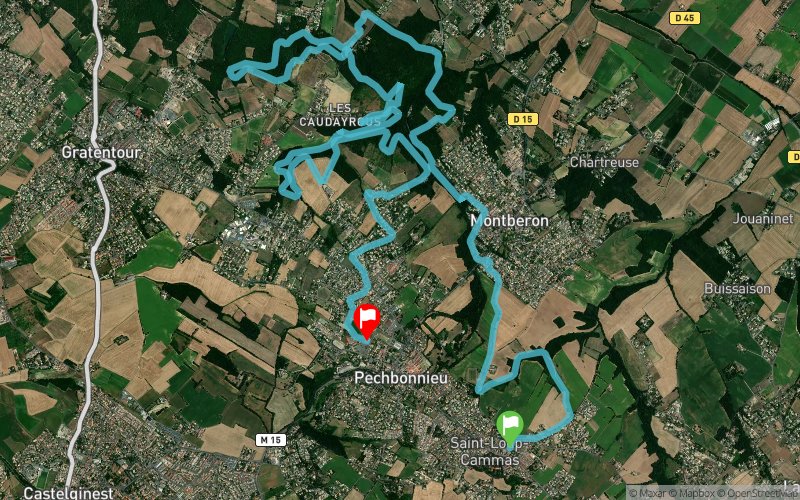


19.9 km
300 m
300 m
 Saint-Loup-Cammas (31)
 Pechbonnieu (31)
 Points of Interest table
| Accum. | Intermediary | |||||||
|---|---|---|---|---|---|---|---|---|
| POI | Description | Alt. | Dist. | D+ | D- | Dist. | D+ | D- |
Trace n°14627
Ascent threshold : 3 m Distance threshold : 30 m Smoothing : Yes Origin of altitudes : MNT Aster GDEM
Ascent threshold : 3 m Distance threshold : 30 m Smoothing : Yes Origin of altitudes : MNT Aster GDEM
Crossing
Dominant terrain : Footpath
Max alti. : 206 m
Avg alti. : 163 m
Min alti. : 131 m
Longest ascent : 60 m
Longest descent : 70 m
Route completed by the author : nc
Dominant terrain : Footpath
Max alti. : 206 m
Avg alti. : 163 m
Min alti. : 131 m
Longest ascent : 60 m
Longest descent : 70 m
Route completed by the author : nc
Elevation profile
More tools
Create a new roadbook page
Map and track on your website
Warning ! When you insert a Trace de Trail map on your website, you agree not to hide any element of the module (links to Trail Trail or Trail Connect banner)
Add a realisation
Validate
Add a realisation to share your chrono and describe the conditions that you encountered during you trail running !
Add a comment
Validate
Thierry Diaz
16/06/19, 19:11:47
La partie entre KM3 et 4 est obsolete (nouvelles construction), a faire par temps très sec car beaucoup de boue dans les bois. Nombreuses ronces et orties
16/06/19, 19:11:47
La partie entre KM3 et 4 est obsolete (nouvelles construction), a faire par temps très sec car beaucoup de boue dans les bois. Nombreuses ronces et orties
Show the infos
Add a track


