Show the map
Ultra Trail du Mont-Blanc 2022 - 157K
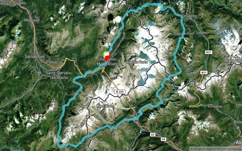


157.1 km
10740 m
10740 m
 Chamonix-Mont-Blanc (74)
 Points of Interest table
| Accum. | Intermediary | |||||||
|---|---|---|---|---|---|---|---|---|
| POI | Description | Alt. | Dist. | D+ | D- | Dist. | D+ | D- |
 Event off organized on 08/27/2020
Trace n°126060
Ascent threshold : 3 m Distance threshold : 30 m Smoothing : No Origin of altitudes : MNT Aster GDEM
Ascent threshold : 3 m Distance threshold : 30 m Smoothing : No Origin of altitudes : MNT Aster GDEM
Loop
Dominant terrain : Path
Max alti. : 2670 m
Avg alti. : 1727 m
Min alti. : 972 m
Longest ascent : 1530 m
Longest descent : 1700 m
Dominant terrain : Path
Max alti. : 2670 m
Avg alti. : 1727 m
Min alti. : 972 m
Longest ascent : 1530 m
Longest descent : 1700 m
Elevation profile
More tools
Create a new roadbook page
Map and track on your website
Warning ! When you insert a Trace de Trail map on your website, you agree not to hide any element of the module (links to Trail Trail or Trail Connect banner)
Add a realisation
Validate
Add a realisation to share your chrono and describe the conditions that you encountered during you trail running !
Add a comment
Validate
degasquetbertrand21
14/08/20, 23:21:27
C est bon. Téléchargement très long mais l intérêt c est surtout d avoir la trace gpx
14/08/20, 23:21:27
C est bon. Téléchargement très long mais l intérêt c est surtout d avoir la trace gpx
Show the infos
Add a track


