Show the map
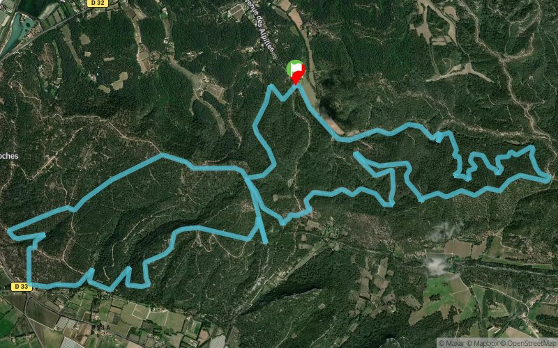
La Lèque - Le Grès du Comte - Les Traversières


19 km
554 m
553 m

Points of Interest table
Accum. | Intermediary | |||||||
---|---|---|---|---|---|---|---|---|
POI | Description | Alt. | Dist. | D+ | D- | Dist. | D+ | D- |
Trace n°11744
Ascent threshold : 3 m Distance threshold : 30 m Smoothing : Yes Origin of altitudes : MNT Aster GDEM
Loop
Dominant terrain : Path
Max alti. : 218 m
Avg alti. : 124 m
Min alti. : 14 m
Longest ascent : 197 m
Longest descent : 182 m
Route completed by the author : nc
Dominant terrain : Path
Max alti. : 218 m
Avg alti. : 124 m
Min alti. : 14 m
Longest ascent : 197 m
Longest descent : 182 m
Route completed by the author : nc
Elevation profile

Their last tracks
More tools
Create a new roadbook page
Carte à la Carte IGN
Map and track on your website
Warning ! When you insert a Trace de Trail map on your website, you agree not to hide any element of the module (links to Trail Trail or Trail Connect banner)
Add a realisation
Validate
Add a realisation to share your chrono and describe the conditions that you encountered during you trail running !
Add a comment
Validate
Nearby tracks
6.9 km Les Quatre Cantons - Plan Redon - Les Traversières
14.9 km
390 m
400 m
Les Baux-de-Provence (13)
8.6 km Chap. St-Gabriel - St-Rémy-de-Provence - Plateau de la Caume - Aureille
52.4 km
1210 m
1130 m
Tarascon (13)
11.0 km Col de Vallongue - Plateau de la Caume - Vallon de St-Clerg
15.7 km
510 m
510 m
Saint-Rémy-de-Provence (13)
11.1 km L'île de Lussan - L'Aiguille - Rocher de Triple Levée - St-Roman
18.3 km
400 m
400 m
Beaucaire (30)
11.2 km La Verdière - Baumayrane - Piste des Lombards
28.7 km
950 m
960 m
Saint-Rémy-de-Provence (13)
11.3 km Séraillet - Col de Vallongue - Plateau de la Caume
15.9 km
650 m
650 m
Saint-Rémy-de-Provence (13)
Show the infos
Add a track