Show the map
Roche Colombe - Grand Pomerolle - Les Berches
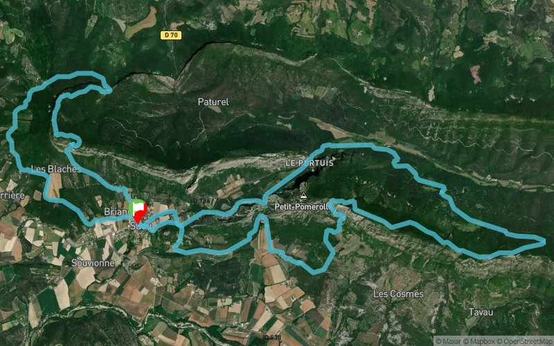


28.1 km
1620 m
1620 m
 Saou (26)
 Points of Interest table
| Accum. | Intermediary | |||||||
|---|---|---|---|---|---|---|---|---|
| POI | Description | Alt. | Dist. | D+ | D- | Dist. | D+ | D- |
Trace n°110101
Ascent threshold : 3 m Distance threshold : 30 m Smoothing : Yes Origin of altitudes : MNT Aster GDEM
Ascent threshold : 3 m Distance threshold : 30 m Smoothing : Yes Origin of altitudes : MNT Aster GDEM
Loop
Dominant terrain : Footpath
Max alti. : 1050 m
Avg alti. : 584 m
Min alti. : 326 m
Longest ascent : 760 m
Longest descent : 820 m
Route completed by the author : No
Dominant terrain : Footpath
Max alti. : 1050 m
Avg alti. : 584 m
Min alti. : 326 m
Longest ascent : 760 m
Longest descent : 820 m
Route completed by the author : No
Elevation profile
More tools
Create a new roadbook page
Map and track on your website
Warning ! When you insert a Trace de Trail map on your website, you agree not to hide any element of the module (links to Trail Trail or Trail Connect banner)
Add a realisation
Validate
Add a realisation to share your chrono and describe the conditions that you encountered during you trail running !
Add a comment
Validate
constantinelefilm
07/10/23, 15:04:46
merci c'est 2 belles difficultés, attention bien gérer l'eau car aucune source d'eau sur le parcours mise à part SAOU et encore quand les fontaines sont ouvertes, par fortes chaleurs, prévoir de faire la boucle de POMEROLLE inverse et monter côté auberge, l'autre côté c'est un four
Show the infos
Add a track


