Show the map
Les Estraquès - Les Gabachoux - Cordes-Tolosannes - Belleperche
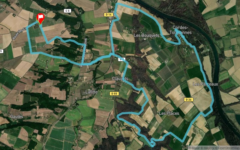


21.6 km
330 m
250 m
 Lafitte (82)
 Lafitte (82)
 Points of Interest table
| Accum. | Intermediary | |||||||
|---|---|---|---|---|---|---|---|---|
| POI | Description | Alt. | Dist. | D+ | D- | Dist. | D+ | D- |
Trace n°102602
Ascent threshold : 3 m Distance threshold : 0 m Smoothing : No Origin of altitudes : TrailConnect Android - GPS
Ascent threshold : 3 m Distance threshold : 0 m Smoothing : No Origin of altitudes : TrailConnect Android - GPS
Loop
Dominant terrain : Path
Max alti. : 215 m
Avg alti. : 160 m
Min alti. : 111 m
Longest ascent : 200 m
Longest descent : 110 m
Route completed by the author : Yes
Dominant terrain : Path
Max alti. : 215 m
Avg alti. : 160 m
Min alti. : 111 m
Longest ascent : 200 m
Longest descent : 110 m
Route completed by the author : Yes
Elevation profile
More tools
Create a new roadbook page
Map and track on your website
Warning ! When you insert a Trace de Trail map on your website, you agree not to hide any element of the module (links to Trail Trail or Trail Connect banner)
Add a realisation
Validate
Add a realisation to share your chrono and describe the conditions that you encountered during you trail running !
Add a comment
Validate
Gilou-82
17/11/19, 20:48:18
Parcours agréable, une bonne partie sur chemin et aussi en sous bois. Terrain boueux et trempé par les dernières pluies
17/11/19, 20:48:18
Parcours agréable, une bonne partie sur chemin et aussi en sous bois. Terrain boueux et trempé par les dernières pluies
Show the infos
Add a track


